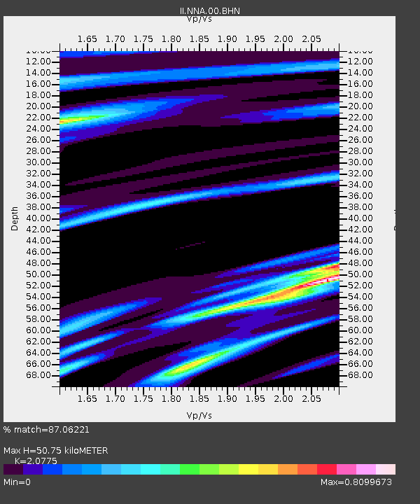
NNA Nana, Peru - Earthquake Result Viewer
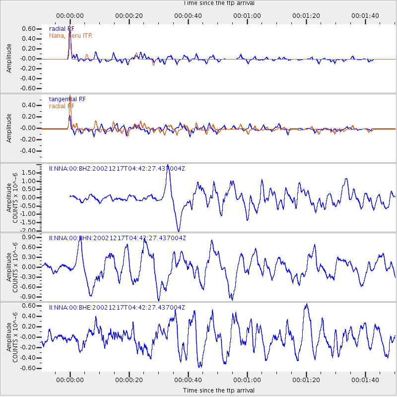
Earthquake location: South Sandwich Islands Region
Earthquake latitude/longitude: -57.0/-24.8
Earthquake time(UTC): 2002/12/17 (351) 04:32:53 GMT
Earthquake Depth: 10 km
Earthquake Magnitude: 5.4 MB, 6.3 MS, 6.2 MW, 6.0 MW
Earthquake Catalog/Contributor: WHDF/NEIC
Network: II Global Seismograph Network (GSN - IRIS/IDA)
Station: NNA Nana, Peru
Lat/Lon: 11.99 S/76.84 W
Elevation: 575 m
Distance: 59.8 deg
Az: 296.865 deg
Baz: 150.031 deg
Ray Param: 0.061931435
Estimated Moho Depth: 50.75 km
Estimated Crust Vp/Vs: 2.08
Assumed Crust Vp: 6.472 km/s
Estimated Crust Vs: 3.115 km/s
Estimated Crust Poisson's Ratio: 0.35
Radial Match: 87.06221 %
Radial Bump: 359
Transverse Match: 74.26796 %
Transverse Bump: 400
SOD ConfigId: 4714
Insert Time: 2010-03-01 19:47:07.263 +0000
GWidth: 2.5
Max Bumps: 400
Tol: 0.001

Signal To Noise

ChannelStoNSTALTA
II:NNA:00:BHN:20021217T04:42:27.437004Z5.78221754.1598577E-77.194225E-8
II:NNA:00:BHE:20021217T04:42:27.437004Z1.25025121.2864051E-71.02891725E-7
II:NNA:00:BHZ:20021217T04:42:27.437004Z7.1155768.882451E-71.2483109E-7
Arrivals
Ps8.8 SECOND
PpPs23 SECOND
PsPs/PpSs32 SECOND