You are here: Home > Network List > TA - USArray Transportable Network (new EarthScope stations) Stations List
> Station O03E Paynes Creek, CA, USA > Earthquake Result Viewer
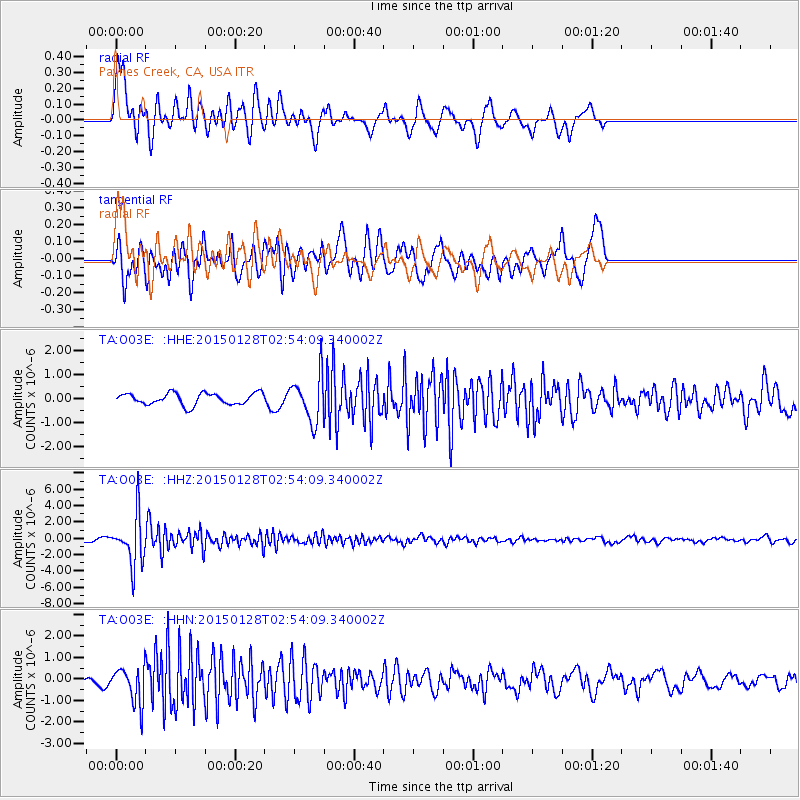
O03E Paynes Creek, CA, USA - Earthquake Result Viewer
*The percent match for this event was below the threshold and hence no stack was calculated.
| Earthquake location: |
Fiji Islands Region |
| Earthquake latitude/longitude: |
-20.9/-178.4 |
| Earthquake time(UTC): |
2015/01/28 (028) 02:43:19 GMT |
| Earthquake Depth: |
484 km |
| Earthquake Magnitude: |
6.1 MWP |
| Earthquake Catalog/Contributor: |
NEIC PDE/NEIC COMCAT |
|
| Network: |
TA USArray Transportable Network (new EarthScope stations) |
| Station: |
O03E Paynes Creek, CA, USA |
| Lat/Lon: |
40.29 N/121.80 W |
| Elevation: |
967 m |
|
| Distance: |
80.5 deg |
| Az: |
40.325 deg |
| Baz: |
232.281 deg |
| Ray Param: |
$rayparam |
*The percent match for this event was below the threshold and hence was not used in the summary stack. |
|
| Radial Match: |
67.316444 % |
| Radial Bump: |
400 |
| Transverse Match: |
76.824776 % |
| Transverse Bump: |
400 |
| SOD ConfigId: |
3390531 |
| Insert Time: |
2019-04-16 04:43:19.962 +0000 |
| GWidth: |
2.5 |
| Max Bumps: |
400 |
| Tol: |
0.001 |
|
Signal To Noise
| Channel | StoN | STA | LTA |
| TA:O03E: :HHZ:20150128T02:54:09.340002Z | 19.036922 | 3.0532565E-6 | 1.6038602E-7 |
| TA:O03E: :HHN:20150128T02:54:09.340002Z | 3.9401019 | 8.543792E-7 | 2.1684191E-7 |
| TA:O03E: :HHE:20150128T02:54:09.340002Z | 3.9601936 | 9.628699E-7 | 2.4313707E-7 |
| Arrivals |
| Ps | |
| PpPs | |
| PsPs/PpSs | |


