You are here: Home > Network List > TA - USArray Transportable Network (new EarthScope stations) Stations List
> Station TPFO Pinon Flats, CA, USA > Earthquake Result Viewer
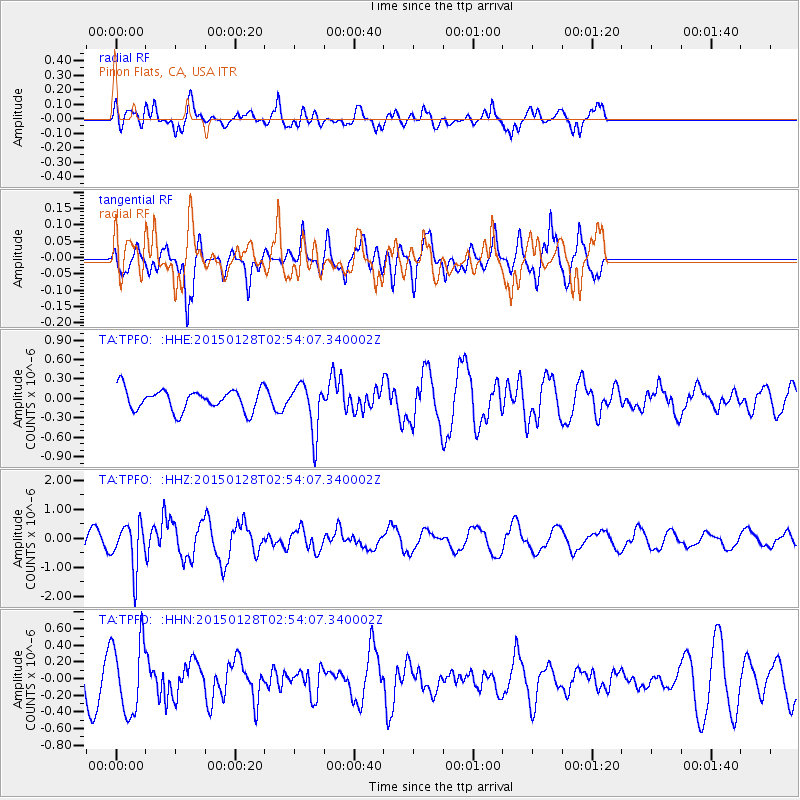
TPFO Pinon Flats, CA, USA - Earthquake Result Viewer
*The percent match for this event was below the threshold and hence no stack was calculated.
| Earthquake location: |
Fiji Islands Region |
| Earthquake latitude/longitude: |
-20.9/-178.4 |
| Earthquake time(UTC): |
2015/01/28 (028) 02:43:19 GMT |
| Earthquake Depth: |
484 km |
| Earthquake Magnitude: |
6.1 MWP |
| Earthquake Catalog/Contributor: |
NEIC PDE/NEIC COMCAT |
|
| Network: |
TA USArray Transportable Network (new EarthScope stations) |
| Station: |
TPFO Pinon Flats, CA, USA |
| Lat/Lon: |
33.61 N/116.45 W |
| Elevation: |
1275 m |
|
| Distance: |
80.1 deg |
| Az: |
48.36 deg |
| Baz: |
236.848 deg |
| Ray Param: |
$rayparam |
*The percent match for this event was below the threshold and hence was not used in the summary stack. |
|
| Radial Match: |
63.51029 % |
| Radial Bump: |
400 |
| Transverse Match: |
53.92177 % |
| Transverse Bump: |
355 |
| SOD ConfigId: |
3390531 |
| Insert Time: |
2019-04-16 04:43:24.595 +0000 |
| GWidth: |
2.5 |
| Max Bumps: |
400 |
| Tol: |
0.001 |
|
Signal To Noise
| Channel | StoN | STA | LTA |
| TA:TPFO: :HHZ:20150128T02:54:07.340002Z | 2.7218664 | 7.716492E-7 | 2.8350004E-7 |
| TA:TPFO: :HHN:20150128T02:54:07.340002Z | 1.5735534 | 4.280795E-7 | 2.7204638E-7 |
| TA:TPFO: :HHE:20150128T02:54:07.340002Z | 2.2771864 | 3.7499683E-7 | 1.6467551E-7 |
| Arrivals |
| Ps | |
| PpPs | |
| PsPs/PpSs | |


