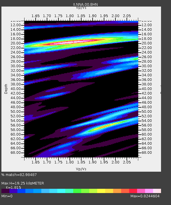
NNA Nana, Peru - Earthquake Result Viewer

Earthquake location: Queen Charlotte Islands Region
Earthquake latitude/longitude: 54.8/-134.2
Earthquake time(UTC): 2004/06/28 (180) 09:49:47 GMT
Earthquake Depth: 20 km
Earthquake Magnitude: 5.9 MB, 6.8 MS, 6.8 MW, 6.8 MW
Earthquake Catalog/Contributor: WHDF/NEIC
Network: II Global Seismograph Network (GSN - IRIS/IDA)
Station: NNA Nana, Peru
Lat/Lon: 11.99 S/76.84 W
Elevation: 575 m
Distance: 82.1 deg
Az: 123.672 deg
Baz: 330.497 deg
Ray Param: 0.04708287
Estimated Moho Depth: 19.25 km
Estimated Crust Vp/Vs: 1.82
Assumed Crust Vp: 6.472 km/s
Estimated Crust Vs: 3.566 km/s
Estimated Crust Poisson's Ratio: 0.28
Radial Match: 82.98487 %
Radial Bump: 400
Transverse Match: 74.13455 %
Transverse Bump: 400
SOD ConfigId: 2459
Insert Time: 2010-03-01 19:47:59.701 +0000
GWidth: 2.5
Max Bumps: 400
Tol: 0.001

Signal To Noise

ChannelStoNSTALTA
II:NNA:00:BHN:20040628T10:01:34.825012Z1.26590013.80827E-73.0083496E-7
II:NNA:00:BHE:20040628T10:01:34.825012Z1.1867853.1731244E-72.6737146E-7
II:NNA:00:BHZ:20040628T10:01:34.825012Z2.6554598.172629E-73.0776712E-7
Arrivals
Ps2.5 SECOND
PpPs8.2 SECOND
PsPs/PpSs11 SECOND