You are here: Home > Network List > II - Global Seismograph Network (GSN - IRIS/IDA) Stations List
> Station NNA Nana, Peru > Earthquake Result Viewer
NNA Nana, Peru - Earthquake Result Viewer
| Earthquake location: |
Strait Of Gibraltar |
| Earthquake latitude/longitude: |
35.1/-4.0 |
| Earthquake time(UTC): |
2004/02/24 (055) 02:27:46 GMT |
| Earthquake Depth: |
0.0 km |
| Earthquake Magnitude: |
6.2 MB, 6.4 MS, 6.4 MW, 6.4 MW |
| Earthquake Catalog/Contributor: |
WHDF/NEIC |
|
| Network: |
II Global Seismograph Network (GSN - IRIS/IDA) |
| Station: |
NNA Nana, Peru |
| Lat/Lon: |
11.99 S/76.84 W |
| Elevation: |
575 m |
|
| Distance: |
83.2 deg |
| Az: |
250.314 deg |
| Baz: |
52.056 deg |
| Ray Param: |
0.04636991 |
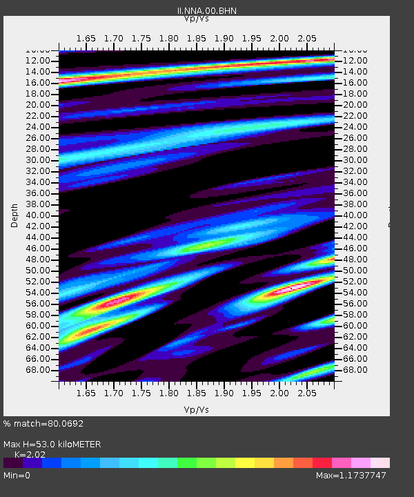
| Estimated Moho Depth: |
53.0 km |
| Estimated Crust Vp/Vs: |
2.02 |
| Assumed Crust Vp: |
6.472 km/s |
| Estimated Crust Vs: |
3.204 km/s |
| Estimated Crust Poisson's Ratio: |
0.34 |
|
| Radial Match: |
80.0692 % |
| Radial Bump: |
400 |
| Transverse Match: |
81.36468 % |
| Transverse Bump: |
400 |
| SOD ConfigId: |
2459 |
| Insert Time: |
2010-03-01 19:48:01.490 +0000 |
| GWidth: |
2.5 |
| Max Bumps: |
400 |
| Tol: |
0.001 |
|

Signal To Noise
| Channel | StoN | STA | LTA |
| II:NNA:00:BHN:20040224T02:39:42.808003Z | 0.8891485 | 1.5888777E-7 | 1.7869655E-7 |
| II:NNA:00:BHE:20040224T02:39:42.808003Z | 1.5037705 | 3.2288895E-7 | 2.1471958E-7 |
| II:NNA:00:BHZ:20040224T02:39:42.808003Z | 3.5160017 | 7.215611E-7 | 2.0522205E-7 |
| Arrivals |
| Ps | 8.5 SECOND |
| PpPs | 24 SECOND |
| PsPs/PpSs | 33 SECOND |


