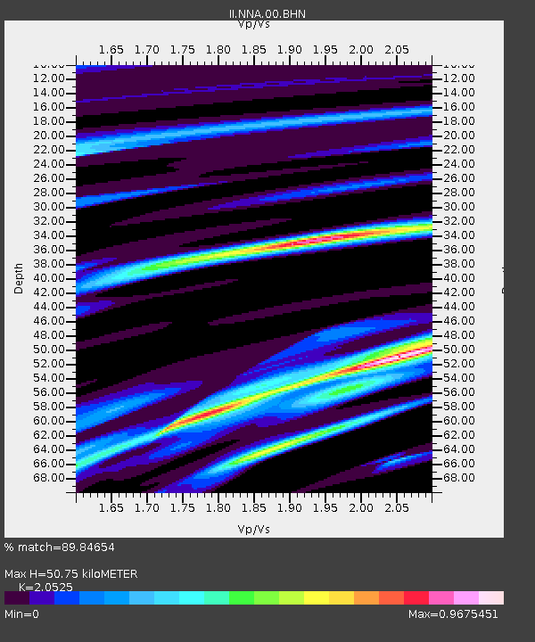
NNA Nana, Peru - Earthquake Result Viewer

Earthquake location: Southwestern Atlantic Ocean
Earthquake latitude/longitude: -58.4/-15.0
Earthquake time(UTC): 2004/02/21 (052) 02:34:42 GMT
Earthquake Depth: 10 km
Earthquake Magnitude: 6.0 MB, 6.5 MS, 6.6 MW, 6.6 MW
Earthquake Catalog/Contributor: WHDF/NEIC
Network: II Global Seismograph Network (GSN - IRIS/IDA)
Station: NNA Nana, Peru
Lat/Lon: 11.99 S/76.84 W
Elevation: 575 m
Distance: 65.3 deg
Az: 288.192 deg
Baz: 149.279 deg
Ray Param: 0.05837433
Estimated Moho Depth: 50.75 km
Estimated Crust Vp/Vs: 2.05
Assumed Crust Vp: 6.472 km/s
Estimated Crust Vs: 3.153 km/s
Estimated Crust Poisson's Ratio: 0.34
Radial Match: 89.84654 %
Radial Bump: 376
Transverse Match: 84.9655 %
Transverse Bump: 400
SOD ConfigId: 2459
Insert Time: 2010-03-01 19:48:04.729 +0000
GWidth: 2.5
Max Bumps: 400
Tol: 0.001

Signal To Noise

ChannelStoNSTALTA
II:NNA:00:BHN:20040221T02:44:53.46001Z2.06146862.6286668E-71.2751428E-7
II:NNA:00:BHE:20040221T02:44:53.46001Z0.61228277.141511E-81.1663747E-7
II:NNA:00:BHZ:20040221T02:44:53.46001Z1.60270424.5291756E-72.8259583E-7
Arrivals
Ps8.6 SECOND
PpPs23 SECOND
PsPs/PpSs32 SECOND