You are here: Home > Network List > UW - Pacific Northwest Regional Seismic Network Stations List
> Station PASS Maple Falls, WA, USA > Earthquake Result Viewer
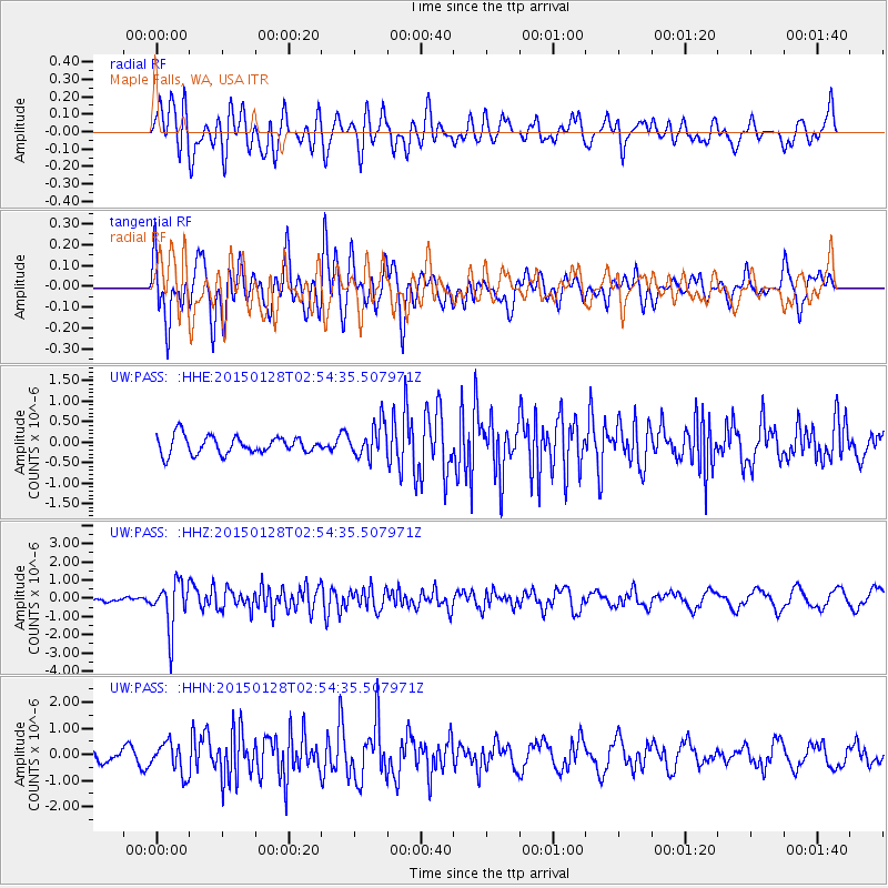
PASS Maple Falls, WA, USA - Earthquake Result Viewer
*The percent match for this event was below the threshold and hence no stack was calculated.
| Earthquake location: |
Fiji Islands Region |
| Earthquake latitude/longitude: |
-20.9/-178.4 |
| Earthquake time(UTC): |
2015/01/28 (028) 02:43:19 GMT |
| Earthquake Depth: |
484 km |
| Earthquake Magnitude: |
6.1 MWP |
| Earthquake Catalog/Contributor: |
NEIC PDE/NEIC COMCAT |
|
| Network: |
UW Pacific Northwest Regional Seismic Network |
| Station: |
PASS Maple Falls, WA, USA |
| Lat/Lon: |
49.00 N/122.09 W |
| Elevation: |
174 m |
|
| Distance: |
85.7 deg |
| Az: |
33.315 deg |
| Baz: |
231.236 deg |
| Ray Param: |
$rayparam |
*The percent match for this event was below the threshold and hence was not used in the summary stack. |
|
| Radial Match: |
65.103516 % |
| Radial Bump: |
400 |
| Transverse Match: |
63.860138 % |
| Transverse Bump: |
400 |
| SOD ConfigId: |
3390531 |
| Insert Time: |
2019-04-16 04:44:31.768 +0000 |
| GWidth: |
2.5 |
| Max Bumps: |
400 |
| Tol: |
0.001 |
|
Signal To Noise
| Channel | StoN | STA | LTA |
| UW:PASS: :HHZ:20150128T02:54:35.507971Z | 5.2272687 | 1.3078843E-6 | 2.5020415E-7 |
| UW:PASS: :HHN:20150128T02:54:35.507971Z | 1.6506233 | 5.9205644E-7 | 3.5868658E-7 |
| UW:PASS: :HHE:20150128T02:54:35.507971Z | 1.936217 | 4.1388708E-7 | 2.137607E-7 |
| Arrivals |
| Ps | |
| PpPs | |
| PsPs/PpSs | |


