You are here: Home > Network List > TA - USArray Transportable Network (new EarthScope stations) Stations List
> Station HDA Harding Lake, AK, USA > Earthquake Result Viewer
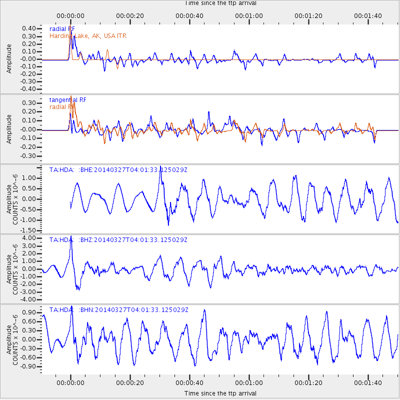
HDA Harding Lake, AK, USA - Earthquake Result Viewer
*The percent match for this event was below the threshold and hence no stack was calculated.
| Earthquake location: |
Santa Cruz Islands |
| Earthquake latitude/longitude: |
-12.1/166.5 |
| Earthquake time(UTC): |
2014/03/27 (086) 03:49:46 GMT |
| Earthquake Depth: |
112 km |
| Earthquake Magnitude: |
5.7 MB, 6.0 MWB, 6.0 MWW, 6.0 MWC |
| Earthquake Catalog/Contributor: |
NEIC PDE/NEIC COMCAT |
|
| Network: |
TA USArray Transportable Network (new EarthScope stations) |
| Station: |
HDA Harding Lake, AK, USA |
| Lat/Lon: |
64.41 N/146.95 W |
| Elevation: |
437 m |
|
| Distance: |
84.0 deg |
| Az: |
18.474 deg |
| Baz: |
225.532 deg |
| Ray Param: |
$rayparam |
*The percent match for this event was below the threshold and hence was not used in the summary stack. |
|
| Radial Match: |
70.711624 % |
| Radial Bump: |
400 |
| Transverse Match: |
67.58268 % |
| Transverse Bump: |
400 |
| SOD ConfigId: |
626651 |
| Insert Time: |
2014-04-21 14:40:36.722 +0000 |
| GWidth: |
2.5 |
| Max Bumps: |
400 |
| Tol: |
0.001 |
|
Signal To Noise
| Channel | StoN | STA | LTA |
| TA:HDA: :BHZ:20140327T04:01:33.125029Z | 4.6930003 | 1.9275544E-6 | 4.1072963E-7 |
| TA:HDA: :BHN:20140327T04:01:33.125029Z | 0.8871115 | 4.9496515E-7 | 5.5795147E-7 |
| TA:HDA: :BHE:20140327T04:01:33.125029Z | 1.9012456 | 7.520185E-7 | 3.955399E-7 |
| Arrivals |
| Ps | |
| PpPs | |
| PsPs/PpSs | |


