You are here: Home > Network List > TA - USArray Transportable Network (new EarthScope stations) Stations List
> Station O03E Paynes Creek, CA, USA > Earthquake Result Viewer
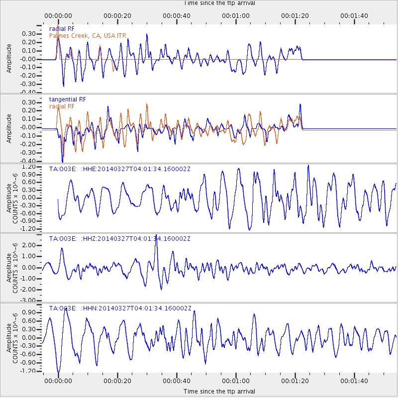
O03E Paynes Creek, CA, USA - Earthquake Result Viewer
*The percent match for this event was below the threshold and hence no stack was calculated.
| Earthquake location: |
Santa Cruz Islands |
| Earthquake latitude/longitude: |
-12.1/166.5 |
| Earthquake time(UTC): |
2014/03/27 (086) 03:49:46 GMT |
| Earthquake Depth: |
112 km |
| Earthquake Magnitude: |
5.7 MB, 6.0 MWB, 6.0 MWW, 6.0 MWC |
| Earthquake Catalog/Contributor: |
NEIC PDE/NEIC COMCAT |
|
| Network: |
TA USArray Transportable Network (new EarthScope stations) |
| Station: |
O03E Paynes Creek, CA, USA |
| Lat/Lon: |
40.29 N/121.80 W |
| Elevation: |
967 m |
|
| Distance: |
84.2 deg |
| Az: |
46.869 deg |
| Baz: |
248.944 deg |
| Ray Param: |
$rayparam |
*The percent match for this event was below the threshold and hence was not used in the summary stack. |
|
| Radial Match: |
67.9433 % |
| Radial Bump: |
400 |
| Transverse Match: |
76.12521 % |
| Transverse Bump: |
365 |
| SOD ConfigId: |
626651 |
| Insert Time: |
2014-04-21 14:41:18.971 +0000 |
| GWidth: |
2.5 |
| Max Bumps: |
400 |
| Tol: |
0.001 |
|
Signal To Noise
| Channel | StoN | STA | LTA |
| TA:O03E: :HHZ:20140327T04:01:34.160002Z | 1.8832047 | 8.5944816E-7 | 4.5637535E-7 |
| TA:O03E: :HHN:20140327T04:01:34.160002Z | 2.3815484 | 8.022434E-7 | 3.368579E-7 |
| TA:O03E: :HHE:20140327T04:01:34.160002Z | 1.0886717 | 4.391806E-7 | 4.034096E-7 |
| Arrivals |
| Ps | |
| PpPs | |
| PsPs/PpSs | |


