You are here: Home > Network List > TA - USArray Transportable Network (new EarthScope stations) Stations List
> Station R11A Troy Canyon, Currant, NV, USA > Earthquake Result Viewer
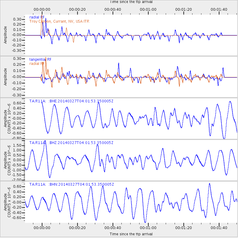
R11A Troy Canyon, Currant, NV, USA - Earthquake Result Viewer
*The percent match for this event was below the threshold and hence no stack was calculated.
| Earthquake location: |
Santa Cruz Islands |
| Earthquake latitude/longitude: |
-12.1/166.5 |
| Earthquake time(UTC): |
2014/03/27 (086) 03:49:46 GMT |
| Earthquake Depth: |
112 km |
| Earthquake Magnitude: |
5.7 MB, 6.0 MWB, 6.0 MWW, 6.0 MWC |
| Earthquake Catalog/Contributor: |
NEIC PDE/NEIC COMCAT |
|
| Network: |
TA USArray Transportable Network (new EarthScope stations) |
| Station: |
R11A Troy Canyon, Currant, NV, USA |
| Lat/Lon: |
38.35 N/115.59 W |
| Elevation: |
1756 m |
|
| Distance: |
88.1 deg |
| Az: |
50.279 deg |
| Baz: |
253.099 deg |
| Ray Param: |
$rayparam |
*The percent match for this event was below the threshold and hence was not used in the summary stack. |
|
| Radial Match: |
61.5419 % |
| Radial Bump: |
400 |
| Transverse Match: |
56.72381 % |
| Transverse Bump: |
390 |
| SOD ConfigId: |
626651 |
| Insert Time: |
2014-04-21 14:41:23.012 +0000 |
| GWidth: |
2.5 |
| Max Bumps: |
400 |
| Tol: |
0.001 |
|
Signal To Noise
| Channel | StoN | STA | LTA |
| TA:R11A: :BHZ:20140327T04:01:53.350005Z | 2.2100663 | 1.22353E-6 | 5.5361687E-7 |
| TA:R11A: :BHN:20140327T04:01:53.350005Z | 0.5780071 | 1.7313559E-7 | 2.9953884E-7 |
| TA:R11A: :BHE:20140327T04:01:53.350005Z | 1.0883179 | 3.646998E-7 | 3.3510412E-7 |
| Arrivals |
| Ps | |
| PpPs | |
| PsPs/PpSs | |


