You are here: Home > Network List > UW - Pacific Northwest Regional Seismic Network Stations List
> Station MRBL Marblemount, WA, USA > Earthquake Result Viewer
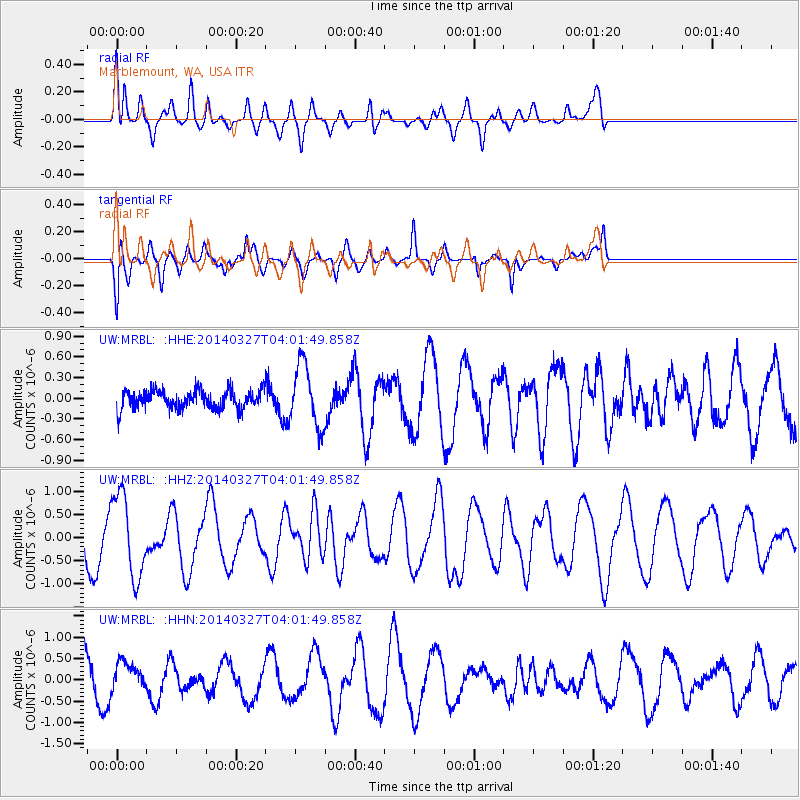
MRBL Marblemount, WA, USA - Earthquake Result Viewer
*The percent match for this event was below the threshold and hence no stack was calculated.
| Earthquake location: |
Santa Cruz Islands |
| Earthquake latitude/longitude: |
-12.1/166.5 |
| Earthquake time(UTC): |
2014/03/27 (086) 03:49:46 GMT |
| Earthquake Depth: |
112 km |
| Earthquake Magnitude: |
5.7 MB, 6.0 MWB, 6.0 MWW, 6.0 MWC |
| Earthquake Catalog/Contributor: |
NEIC PDE/NEIC COMCAT |
|
| Network: |
UW Pacific Northwest Regional Seismic Network |
| Station: |
MRBL Marblemount, WA, USA |
| Lat/Lon: |
48.52 N/121.48 W |
| Elevation: |
75 m |
|
| Distance: |
87.4 deg |
| Az: |
39.267 deg |
| Baz: |
248.607 deg |
| Ray Param: |
$rayparam |
*The percent match for this event was below the threshold and hence was not used in the summary stack. |
|
| Radial Match: |
65.23561 % |
| Radial Bump: |
400 |
| Transverse Match: |
48.92516 % |
| Transverse Bump: |
321 |
| SOD ConfigId: |
626651 |
| Insert Time: |
2014-04-21 14:43:34.698 +0000 |
| GWidth: |
2.5 |
| Max Bumps: |
400 |
| Tol: |
0.001 |
|
Signal To Noise
| Channel | StoN | STA | LTA |
| UW:MRBL: :HHZ:20140327T04:01:49.858Z | 2.4650714 | 8.8835355E-7 | 3.6037642E-7 |
| UW:MRBL: :HHN:20140327T04:01:49.858Z | 0.46916658 | 3.1807247E-7 | 6.7795213E-7 |
| UW:MRBL: :HHE:20140327T04:01:49.858Z | 3.2925076 | 4.4984296E-7 | 1.3662624E-7 |
| Arrivals |
| Ps | |
| PpPs | |
| PsPs/PpSs | |


