You are here: Home > Network List > TA - USArray Transportable Network (new EarthScope stations) Stations List
> Station T52A Hallie, KY, USA > Earthquake Result Viewer
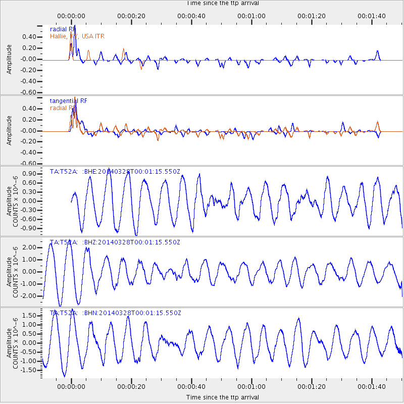
T52A Hallie, KY, USA - Earthquake Result Viewer
*The percent match for this event was below the threshold and hence no stack was calculated.
| Earthquake location: |
San Juan Province, Argentina |
| Earthquake latitude/longitude: |
-29.1/-68.7 |
| Earthquake time(UTC): |
2014/03/27 (086) 23:50:52 GMT |
| Earthquake Depth: |
9.9 km |
| Earthquake Magnitude: |
5.5 MWP, 5.6 MWB, 5.7 MWW, 5.7 MWC |
| Earthquake Catalog/Contributor: |
NEIC PDE/NEIC COMCAT |
|
| Network: |
TA USArray Transportable Network (new EarthScope stations) |
| Station: |
T52A Hallie, KY, USA |
| Lat/Lon: |
37.11 N/82.99 W |
| Elevation: |
436 m |
|
| Distance: |
67.2 deg |
| Az: |
347.655 deg |
| Baz: |
166.468 deg |
| Ray Param: |
$rayparam |
*The percent match for this event was below the threshold and hence was not used in the summary stack. |
|
| Radial Match: |
87.02539 % |
| Radial Bump: |
400 |
| Transverse Match: |
74.285576 % |
| Transverse Bump: |
400 |
| SOD ConfigId: |
626651 |
| Insert Time: |
2014-04-21 15:22:04.706 +0000 |
| GWidth: |
2.5 |
| Max Bumps: |
400 |
| Tol: |
0.001 |
|
Signal To Noise
| Channel | StoN | STA | LTA |
| TA:T52A: :BHZ:20140328T00:01:15.550Z | 1.3371353 | 1.8864231E-6 | 1.4107945E-6 |
| TA:T52A: :BHN:20140328T00:01:15.550Z | 1.3333348 | 1.102957E-6 | 8.272168E-7 |
| TA:T52A: :BHE:20140328T00:01:15.550Z | 0.8226009 | 5.4004346E-7 | 6.565072E-7 |
| Arrivals |
| Ps | |
| PpPs | |
| PsPs/PpSs | |


