You are here: Home > Network List > G - GEOSCOPE Stations List
> Station MPG Montagne des Peres, French Guyana > Earthquake Result Viewer
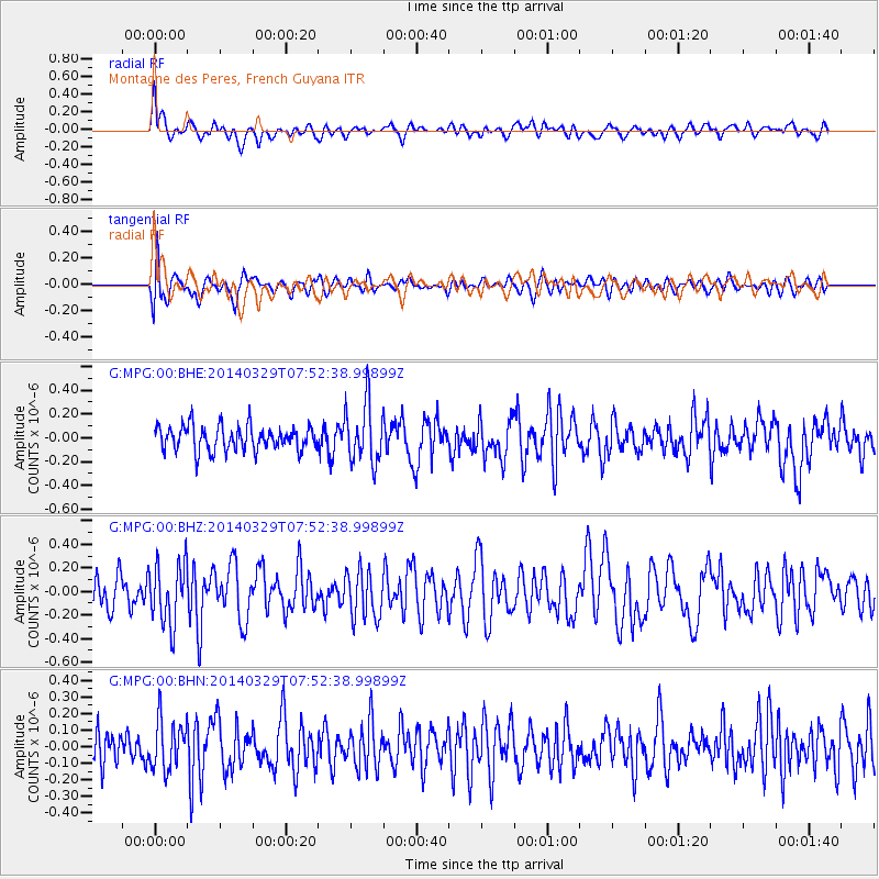
MPG Montagne des Peres, French Guyana - Earthquake Result Viewer
*The percent match for this event was below the threshold and hence no stack was calculated.
| Earthquake location: |
Central Mid-Atlantic Ridge |
| Earthquake latitude/longitude: |
-0.8/-21.9 |
| Earthquake time(UTC): |
2014/03/29 (088) 07:46:50 GMT |
| Earthquake Depth: |
12 km |
| Earthquake Magnitude: |
5.9 MWW, 5.8 MWB, 6.0 MWC |
| Earthquake Catalog/Contributor: |
NEIC PDE/NEIC COMCAT |
|
| Network: |
G GEOSCOPE |
| Station: |
MPG Montagne des Peres, French Guyana |
| Lat/Lon: |
5.11 N/52.64 W |
| Elevation: |
147 m |
|
| Distance: |
31.3 deg |
| Az: |
281.231 deg |
| Baz: |
100.067 deg |
| Ray Param: |
$rayparam |
*The percent match for this event was below the threshold and hence was not used in the summary stack. |
|
| Radial Match: |
57.803986 % |
| Radial Bump: |
400 |
| Transverse Match: |
60.653294 % |
| Transverse Bump: |
400 |
| SOD ConfigId: |
626651 |
| Insert Time: |
2014-04-21 15:48:37.049 +0000 |
| GWidth: |
2.5 |
| Max Bumps: |
400 |
| Tol: |
0.001 |
|
Signal To Noise
| Channel | StoN | STA | LTA |
| G:MPG:00:BHZ:20140329T07:52:38.99899Z | 1.7704369 | 2.6342005E-7 | 1.4878816E-7 |
| G:MPG:00:BHN:20140329T07:52:38.99899Z | 1.3828905 | 1.4886147E-7 | 1.07645164E-7 |
| G:MPG:00:BHE:20140329T07:52:38.99899Z | 2.4812043 | 2.539069E-7 | 1.0233212E-7 |
| Arrivals |
| Ps | |
| PpPs | |
| PsPs/PpSs | |


