You are here: Home > Network List > II - Global Seismograph Network (GSN - IRIS/IDA) Stations List
> Station NNA Nana, Peru > Earthquake Result Viewer
NNA Nana, Peru - Earthquake Result Viewer
| Earthquake location: |
Southwestern Atlantic Ocean |
| Earthquake latitude/longitude: |
-59.9/-18.5 |
| Earthquake time(UTC): |
1994/05/06 (126) 18:20:38 GMT |
| Earthquake Depth: |
10 km |
| Earthquake Magnitude: |
5.3 MB, 5.7 MS |
| Earthquake Catalog/Contributor: |
WHDF/NEIC |
|
| Network: |
II Global Seismograph Network (GSN - IRIS/IDA) |
| Station: |
NNA Nana, Peru |
| Lat/Lon: |
11.99 S/76.84 W |
| Elevation: |
575 m |
|
| Distance: |
64.1 deg |
| Az: |
292.197 deg |
| Baz: |
151.555 deg |
| Ray Param: |
0.05914242 |
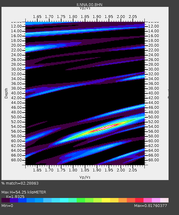
| Estimated Moho Depth: |
54.25 km |
| Estimated Crust Vp/Vs: |
1.93 |
| Assumed Crust Vp: |
6.472 km/s |
| Estimated Crust Vs: |
3.349 km/s |
| Estimated Crust Poisson's Ratio: |
0.32 |
|
| Radial Match: |
82.28863 % |
| Radial Bump: |
400 |
| Transverse Match: |
75.86593 % |
| Transverse Bump: |
400 |
| SOD ConfigId: |
17000 |
| Insert Time: |
2010-03-01 19:49:37.610 +0000 |
| GWidth: |
2.5 |
| Max Bumps: |
400 |
| Tol: |
0.001 |
|

Signal To Noise
| Channel | StoN | STA | LTA |
| II:NNA:00:BHN:19940506T18:30:41.165002Z | 2.4254174 | 3.0356887E-7 | 1.2516149E-7 |
| II:NNA:00:BHE:19940506T18:30:41.14303Z | 1.0485553 | 1.5308318E-7 | 1.4599439E-7 |
| II:NNA:00:BHZ:19940506T18:30:41.165002Z | 3.3391347 | 6.510995E-7 | 1.949905E-7 |
| Arrivals |
| Ps | 8.1 SECOND |
| PpPs | 24 SECOND |
| PsPs/PpSs | 32 SECOND |


