You are here: Home > Network List > II - Global Seismograph Network (GSN - IRIS/IDA) Stations List
> Station NNA Nana, Peru > Earthquake Result Viewer
NNA Nana, Peru - Earthquake Result Viewer
| Earthquake location: |
Baja California, Mexico |
| Earthquake latitude/longitude: |
24.6/-110.3 |
| Earthquake time(UTC): |
1995/06/30 (181) 11:58:56 GMT |
| Earthquake Depth: |
10 km |
| Earthquake Magnitude: |
5.8 MB, 6.3 MS, 6.2 UNKNOWN |
| Earthquake Catalog/Contributor: |
WHDF/NEIC |
|
| Network: |
II Global Seismograph Network (GSN - IRIS/IDA) |
| Station: |
NNA Nana, Peru |
| Lat/Lon: |
11.99 S/76.84 W |
| Elevation: |
575 m |
|
| Distance: |
48.9 deg |
| Az: |
134.313 deg |
| Baz: |
318.275 deg |
| Ray Param: |
0.06907414 |
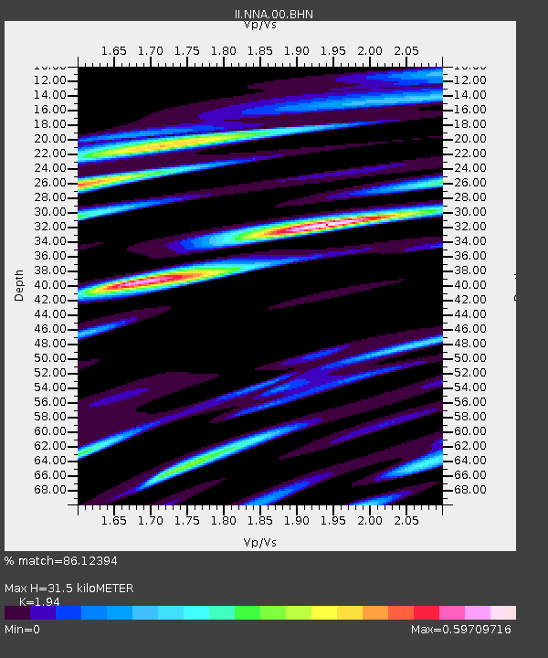
| Estimated Moho Depth: |
31.5 km |
| Estimated Crust Vp/Vs: |
1.94 |
| Assumed Crust Vp: |
6.472 km/s |
| Estimated Crust Vs: |
3.336 km/s |
| Estimated Crust Poisson's Ratio: |
0.32 |
|
| Radial Match: |
86.12394 % |
| Radial Bump: |
400 |
| Transverse Match: |
77.54068 % |
| Transverse Bump: |
400 |
| SOD ConfigId: |
6273 |
| Insert Time: |
2010-03-01 19:49:46.518 +0000 |
| GWidth: |
2.5 |
| Max Bumps: |
400 |
| Tol: |
0.001 |
|

Signal To Noise
| Channel | StoN | STA | LTA |
| II:NNA:00:BHN:19950630T12:07:11.152014Z | 1.9460369 | 2.2648601E-7 | 1.16383205E-7 |
| II:NNA:00:BHE:19950630T12:07:11.152014Z | 2.9549801 | 3.477107E-7 | 1.17669394E-7 |
| II:NNA:00:BHZ:19950630T12:07:11.152014Z | 5.579437 | 5.4581943E-7 | 9.782698E-8 |
| Arrivals |
| Ps | 4.8 SECOND |
| PpPs | 14 SECOND |
| PsPs/PpSs | 18 SECOND |


