You are here: Home > Network List > II - Global Seismograph Network (GSN - IRIS/IDA) Stations List
> Station NNA Nana, Peru > Earthquake Result Viewer
NNA Nana, Peru - Earthquake Result Viewer
| Earthquake location: |
Caribbean Sea |
| Earthquake latitude/longitude: |
18.8/-81.7 |
| Earthquake time(UTC): |
1995/06/27 (178) 10:09:58 GMT |
| Earthquake Depth: |
10 km |
| Earthquake Magnitude: |
5.7 MB, 5.6 MS, 6.2 UNKNOWN, 6.1 MW |
| Earthquake Catalog/Contributor: |
WHDF/NEIC |
|
| Network: |
II Global Seismograph Network (GSN - IRIS/IDA) |
| Station: |
NNA Nana, Peru |
| Lat/Lon: |
11.99 S/76.84 W |
| Elevation: |
575 m |
|
| Distance: |
31.0 deg |
| Az: |
170.689 deg |
| Baz: |
350.99 deg |
| Ray Param: |
0.079180226 |
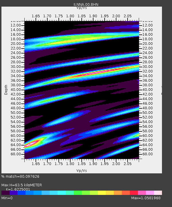
| Estimated Moho Depth: |
63.5 km |
| Estimated Crust Vp/Vs: |
1.62 |
| Assumed Crust Vp: |
6.472 km/s |
| Estimated Crust Vs: |
3.989 km/s |
| Estimated Crust Poisson's Ratio: |
0.19 |
|
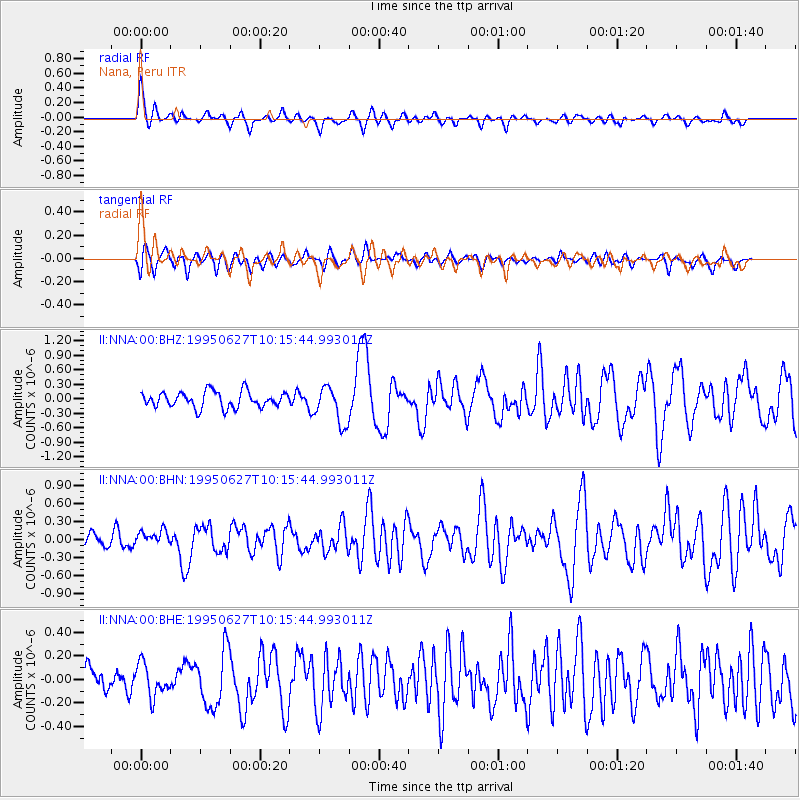
| Radial Match: |
80.097626 % |
| Radial Bump: |
400 |
| Transverse Match: |
68.35176 % |
| Transverse Bump: |
400 |
| SOD ConfigId: |
61242 |
| Insert Time: |
2010-03-01 19:49:51.364 +0000 |
| GWidth: |
2.5 |
| Max Bumps: |
400 |
| Tol: |
0.001 |
|
Signal To Noise
| Channel | StoN | STA | LTA |
| II:NNA:00:BHN:19950627T10:15:44.993011Z | 0.9769432 | 1.2267105E-7 | 1.255662E-7 |
| II:NNA:00:BHE:19950627T10:15:44.993011Z | 1.0650046 | 1.3882926E-7 | 1.3035555E-7 |
| II:NNA:00:BHZ:19950627T10:15:44.993011Z | 2.336256 | 3.8789372E-7 | 1.6603221E-7 |
| Arrivals |
| Ps | 6.7 SECOND |
| PpPs | 24 SECOND |
| PsPs/PpSs | 30 SECOND |


