You are here: Home > Network List > TA - USArray Transportable Network (new EarthScope stations) Stations List
> Station H17A Grant Village (NPS), Yellowstone Nt. Park, WY, USA > Earthquake Result Viewer
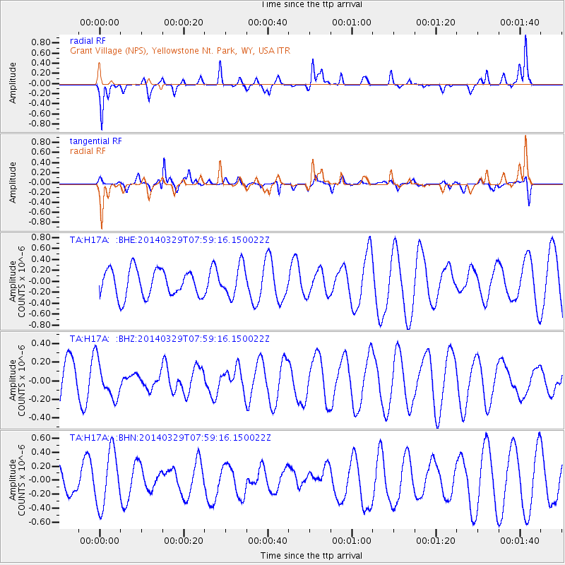
H17A Grant Village (NPS), Yellowstone Nt. Park, WY, USA - Earthquake Result Viewer
*The percent match for this event was below the threshold and hence no stack was calculated.
| Earthquake location: |
Central Mid-Atlantic Ridge |
| Earthquake latitude/longitude: |
-0.8/-21.9 |
| Earthquake time(UTC): |
2014/03/29 (088) 07:46:50 GMT |
| Earthquake Depth: |
12 km |
| Earthquake Magnitude: |
5.9 MWW, 5.8 MWB, 6.0 MWC |
| Earthquake Catalog/Contributor: |
NEIC PDE/NEIC COMCAT |
|
| Network: |
TA USArray Transportable Network (new EarthScope stations) |
| Station: |
H17A Grant Village (NPS), Yellowstone Nt. Park, WY, USA |
| Lat/Lon: |
44.40 N/110.58 W |
| Elevation: |
2400 m |
|
| Distance: |
89.6 deg |
| Az: |
314.218 deg |
| Baz: |
91.54 deg |
| Ray Param: |
$rayparam |
*The percent match for this event was below the threshold and hence was not used in the summary stack. |
|
| Radial Match: |
47.516644 % |
| Radial Bump: |
252 |
| Transverse Match: |
53.91318 % |
| Transverse Bump: |
333 |
| SOD ConfigId: |
626651 |
| Insert Time: |
2014-04-21 16:10:20.456 +0000 |
| GWidth: |
2.5 |
| Max Bumps: |
400 |
| Tol: |
0.001 |
|
Signal To Noise
| Channel | StoN | STA | LTA |
| TA:H17A: :BHZ:20140329T07:59:16.150022Z | 0.8244814 | 1.9261499E-7 | 2.3361957E-7 |
| TA:H17A: :BHN:20140329T07:59:16.150022Z | 2.8812582 | 4.056158E-7 | 1.407773E-7 |
| TA:H17A: :BHE:20140329T07:59:16.150022Z | 1.1678344 | 2.859217E-7 | 2.448307E-7 |
| Arrivals |
| Ps | |
| PpPs | |
| PsPs/PpSs | |


