You are here: Home > Network List > TA - USArray Transportable Network (new EarthScope stations) Stations List
> Station T53A Wise, VA, USA > Earthquake Result Viewer
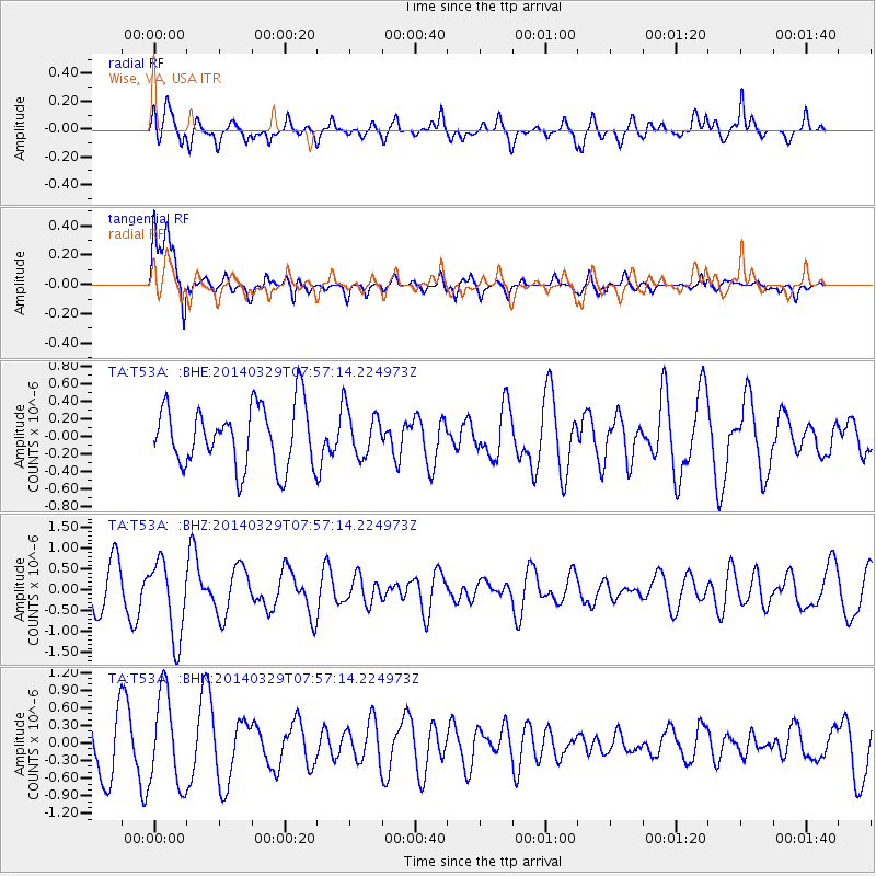
T53A Wise, VA, USA - Earthquake Result Viewer
*The percent match for this event was below the threshold and hence no stack was calculated.
| Earthquake location: |
Central Mid-Atlantic Ridge |
| Earthquake latitude/longitude: |
-0.8/-21.9 |
| Earthquake time(UTC): |
2014/03/29 (088) 07:46:50 GMT |
| Earthquake Depth: |
12 km |
| Earthquake Magnitude: |
5.9 MWW, 5.8 MWB, 6.0 MWC |
| Earthquake Catalog/Contributor: |
NEIC PDE/NEIC COMCAT |
|
| Network: |
TA USArray Transportable Network (new EarthScope stations) |
| Station: |
T53A Wise, VA, USA |
| Lat/Lon: |
36.98 N/82.54 W |
| Elevation: |
818 m |
|
| Distance: |
67.4 deg |
| Az: |
310.914 deg |
| Baz: |
109.331 deg |
| Ray Param: |
$rayparam |
*The percent match for this event was below the threshold and hence was not used in the summary stack. |
|
| Radial Match: |
67.75645 % |
| Radial Bump: |
400 |
| Transverse Match: |
79.97778 % |
| Transverse Bump: |
400 |
| SOD ConfigId: |
626651 |
| Insert Time: |
2014-04-21 16:20:00.776 +0000 |
| GWidth: |
2.5 |
| Max Bumps: |
400 |
| Tol: |
0.001 |
|
Signal To Noise
| Channel | StoN | STA | LTA |
| TA:T53A: :BHZ:20140329T07:57:14.224973Z | 2.4331357 | 9.2664146E-7 | 3.808425E-7 |
| TA:T53A: :BHN:20140329T07:57:14.224973Z | 1.9659338 | 7.8428553E-7 | 3.9893789E-7 |
| TA:T53A: :BHE:20140329T07:57:14.224973Z | 0.7665321 | 2.671085E-7 | 3.4846354E-7 |
| Arrivals |
| Ps | |
| PpPs | |
| PsPs/PpSs | |


