You are here: Home > Network List > TA - USArray Transportable Network (new EarthScope stations) Stations List
> Station Z41A Richland Creek Farm, El Dorado, AR, USA > Earthquake Result Viewer
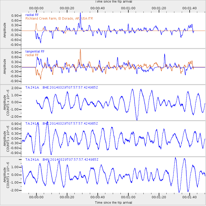
Z41A Richland Creek Farm, El Dorado, AR, USA - Earthquake Result Viewer
*The percent match for this event was below the threshold and hence no stack was calculated.
| Earthquake location: |
Central Mid-Atlantic Ridge |
| Earthquake latitude/longitude: |
-0.8/-21.9 |
| Earthquake time(UTC): |
2014/03/29 (088) 07:46:50 GMT |
| Earthquake Depth: |
12 km |
| Earthquake Magnitude: |
5.9 MWW, 5.8 MWB, 6.0 MWC |
| Earthquake Catalog/Contributor: |
NEIC PDE/NEIC COMCAT |
|
| Network: |
TA USArray Transportable Network (new EarthScope stations) |
| Station: |
Z41A Richland Creek Farm, El Dorado, AR, USA |
| Lat/Lon: |
33.26 N/92.80 W |
| Elevation: |
62 m |
|
| Distance: |
74.6 deg |
| Az: |
304.779 deg |
| Baz: |
101.433 deg |
| Ray Param: |
$rayparam |
*The percent match for this event was below the threshold and hence was not used in the summary stack. |
|
| Radial Match: |
70.26923 % |
| Radial Bump: |
400 |
| Transverse Match: |
61.42543 % |
| Transverse Bump: |
400 |
| SOD ConfigId: |
626651 |
| Insert Time: |
2014-04-21 16:21:27.498 +0000 |
| GWidth: |
2.5 |
| Max Bumps: |
400 |
| Tol: |
0.001 |
|
Signal To Noise
| Channel | StoN | STA | LTA |
| TA:Z41A: :BHZ:20140329T07:57:57.424985Z | 1.533121 | 6.309231E-7 | 4.115286E-7 |
| TA:Z41A: :BHN:20140329T07:57:57.424985Z | 1.6532964 | 8.666755E-7 | 5.2421063E-7 |
| TA:Z41A: :BHE:20140329T07:57:57.424985Z | 0.6430903 | 4.4171887E-7 | 6.868691E-7 |
| Arrivals |
| Ps | |
| PpPs | |
| PsPs/PpSs | |


