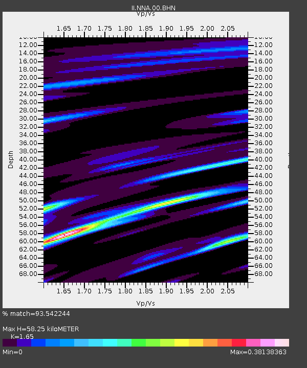
NNA Nana, Peru - Earthquake Result Viewer
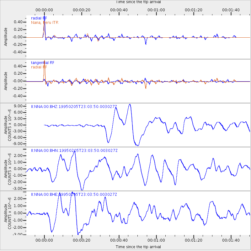
Earthquake location: Off E. Coast Of N. Island, N.Z.
Earthquake latitude/longitude: -37.7/178.8
Earthquake time(UTC): 1995/02/05 (036) 22:51:10 GMT
Earthquake Depth: 59 km
Earthquake Magnitude: 6.4 MB, 7.1 UNKNOWN, 7.1 MW
Earthquake Catalog/Contributor: WHDF/NEIC
Network: II Global Seismograph Network (GSN - IRIS/IDA)
Station: NNA Nana, Peru
Lat/Lon: 11.99 S/76.84 W
Elevation: 575 m
Distance: 93.8 deg
Az: 108.209 deg
Baz: 230.346 deg
Ray Param: 0.041148514
Estimated Moho Depth: 58.25 km
Estimated Crust Vp/Vs: 1.65
Assumed Crust Vp: 6.472 km/s
Estimated Crust Vs: 3.922 km/s
Estimated Crust Poisson's Ratio: 0.21
Radial Match: 93.542244 %
Radial Bump: 383
Transverse Match: 84.113464 %
Transverse Bump: 400
SOD ConfigId: 61242
Insert Time: 2010-03-01 19:49:56.737 +0000
GWidth: 2.5
Max Bumps: 400
Tol: 0.001

Signal To Noise

ChannelStoNSTALTA
II:NNA:00:BHN:19950205T23:03:50.003027Z5.0054148.890528E-71.7761823E-7
II:NNA:00:BHE:19950205T23:03:50.003027Z7.9195821.2868445E-61.6248894E-7
II:NNA:00:BHZ:19950205T23:03:50.003027Z16.938353.8442117E-62.2695313E-7
Arrivals
Ps6.0 SECOND
PpPs23 SECOND
PsPs/PpSs29 SECOND