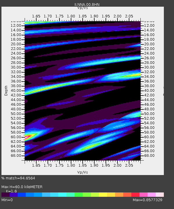
NNA Nana, Peru - Earthquake Result Viewer
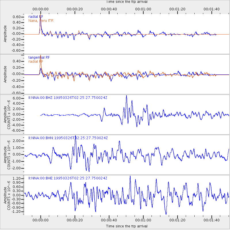
Earthquake location: South Sandwich Islands Region
Earthquake latitude/longitude: -55.9/-28.2
Earthquake time(UTC): 1995/03/26 (085) 02:16:16 GMT
Earthquake Depth: 77 km
Earthquake Magnitude: 6.1 MB, 5.9 MS, 6.4 UNKNOWN, 6.3 MW
Earthquake Catalog/Contributor: WHDF/NEIC
Network: II Global Seismograph Network (GSN - IRIS/IDA)
Station: NNA Nana, Peru
Lat/Lon: 11.99 S/76.84 W
Elevation: 575 m
Distance: 57.7 deg
Az: 299.63 deg
Baz: 149.939 deg
Ray Param: 0.06314513
Estimated Moho Depth: 60.0 km
Estimated Crust Vp/Vs: 1.60
Assumed Crust Vp: 6.472 km/s
Estimated Crust Vs: 4.045 km/s
Estimated Crust Poisson's Ratio: 0.18
Radial Match: 94.6564 %
Radial Bump: 400
Transverse Match: 85.46542 %
Transverse Bump: 400
SOD ConfigId: 61242
Insert Time: 2010-03-01 19:50:02.488 +0000
GWidth: 2.5
Max Bumps: 400
Tol: 0.001

Signal To Noise

ChannelStoNSTALTA
II:NNA:00:BHN:19950326T02:25:27.750024Z0.99950691.5383195E-71.5390785E-7
II:NNA:00:BHE:19950326T02:25:27.750024Z0.949122851.02340564E-71.0782647E-7
II:NNA:00:BHZ:19950326T02:25:27.750024Z0.878183961.4925651E-71.6996042E-7
Arrivals
Ps5.9 SECOND
PpPs23 SECOND
PsPs/PpSs29 SECOND