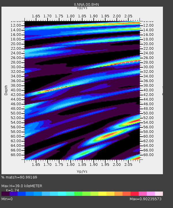
NNA Nana, Peru - Earthquake Result Viewer

Earthquake location: Northern Mid-Atlantic Ridge
Earthquake latitude/longitude: 10.8/-42.3
Earthquake time(UTC): 1996/06/02 (154) 02:52:09 GMT
Earthquake Depth: 10 km
Earthquake Magnitude: 6.1 MB, 6.9 MS, 7.0 UNKNOWN, 6.8 MW
Earthquake Catalog/Contributor: WHDF/NEIC
Network: II Global Seismograph Network (GSN - IRIS/IDA)
Station: NNA Nana, Peru
Lat/Lon: 11.99 S/76.84 W
Elevation: 575 m
Distance: 41.1 deg
Az: 237.586 deg
Baz: 57.962 deg
Ray Param: 0.07397603
Estimated Moho Depth: 39.0 km
Estimated Crust Vp/Vs: 1.74
Assumed Crust Vp: 6.472 km/s
Estimated Crust Vs: 3.719 km/s
Estimated Crust Poisson's Ratio: 0.25
Radial Match: 90.99169 %
Radial Bump: 395
Transverse Match: 65.71593 %
Transverse Bump: 400
SOD ConfigId: 6273
Insert Time: 2010-03-01 19:50:20.094 +0000
GWidth: 2.5
Max Bumps: 400
Tol: 0.001

Signal To Noise

ChannelStoNSTALTA
II:NNA:00:BHN:19960602T02:59:22.928986Z6.16683631.3370571E-62.1681412E-7
II:NNA:00:BHE:19960602T02:59:22.928986Z10.4079771.9785437E-61.9009877E-7
II:NNA:00:BHZ:19960602T02:59:22.932007Z22.910245.3958706E-62.3552222E-7
Arrivals
Ps4.8 SECOND
PpPs15 SECOND
PsPs/PpSs20 SECOND