You are here: Home > Network List > TA - USArray Transportable Network (new EarthScope stations) Stations List
> Station N23A Red Feather Lakes, CO, USA > Earthquake Result Viewer
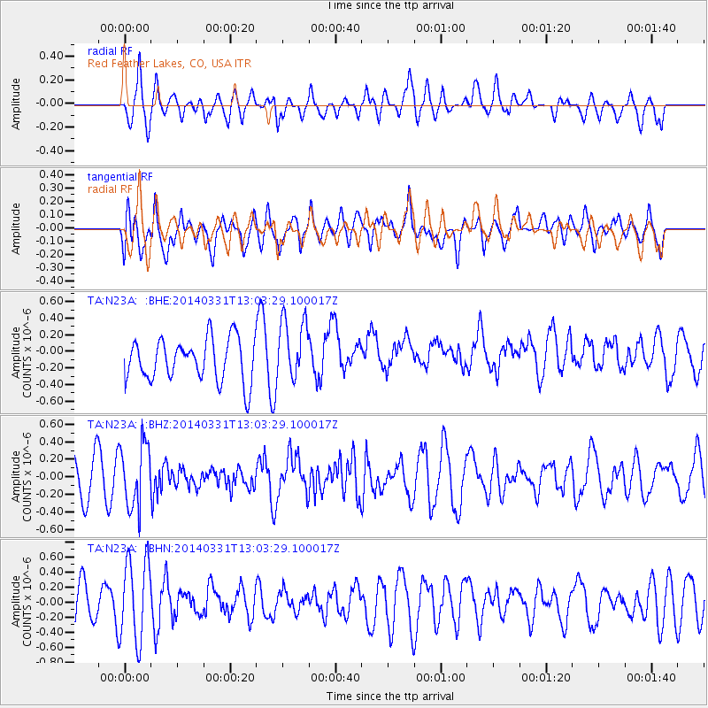
N23A Red Feather Lakes, CO, USA - Earthquake Result Viewer
*The percent match for this event was below the threshold and hence no stack was calculated.
| Earthquake location: |
Northern Chile |
| Earthquake latitude/longitude: |
-19.5/-69.2 |
| Earthquake time(UTC): |
2014/03/31 (090) 12:53:05 GMT |
| Earthquake Depth: |
112 km |
| Earthquake Magnitude: |
5.6 MB, 5.5 MWB, 5.6 MWC, 5.6 MWW |
| Earthquake Catalog/Contributor: |
NEIC PDE/NEIC COMCAT |
|
| Network: |
TA USArray Transportable Network (new EarthScope stations) |
| Station: |
N23A Red Feather Lakes, CO, USA |
| Lat/Lon: |
40.89 N/105.94 W |
| Elevation: |
2458 m |
|
| Distance: |
69.1 deg |
| Az: |
330.947 deg |
| Baz: |
142.827 deg |
| Ray Param: |
$rayparam |
*The percent match for this event was below the threshold and hence was not used in the summary stack. |
|
| Radial Match: |
42.89133 % |
| Radial Bump: |
391 |
| Transverse Match: |
57.192833 % |
| Transverse Bump: |
400 |
| SOD ConfigId: |
626651 |
| Insert Time: |
2014-04-21 17:09:09.175 +0000 |
| GWidth: |
2.5 |
| Max Bumps: |
400 |
| Tol: |
0.001 |
|
Signal To Noise
| Channel | StoN | STA | LTA |
| TA:N23A: :BHZ:20140331T13:03:29.100017Z | 1.5393097 | 3.5725984E-7 | 2.3209094E-7 |
| TA:N23A: :BHN:20140331T13:03:29.100017Z | 1.7935654 | 5.523281E-7 | 3.079498E-7 |
| TA:N23A: :BHE:20140331T13:03:29.100017Z | 1.5017256 | 3.804831E-7 | 2.5336396E-7 |
| Arrivals |
| Ps | |
| PpPs | |
| PsPs/PpSs | |


