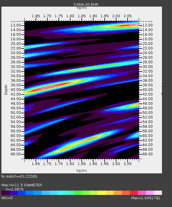
NNA Nana, Peru - Earthquake Result Viewer
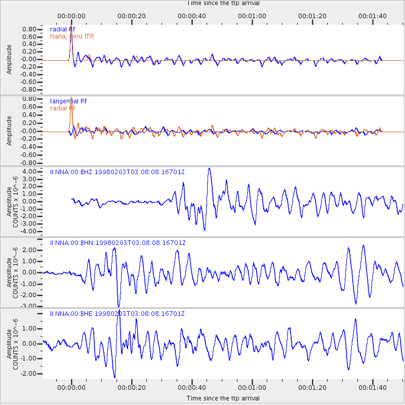
Earthquake location: Near Coast Of Oaxaca, Mexico
Earthquake latitude/longitude: 15.9/-96.3
Earthquake time(UTC): 1998/02/03 (034) 03:02:00 GMT
Earthquake Depth: 33 km
Earthquake Magnitude: 6.0 MB, 6.2 MS, 6.3 UNKNOWN, 6.4 MD
Earthquake Catalog/Contributor: WHDF/NEIC
Network: II Global Seismograph Network (GSN - IRIS/IDA)
Station: NNA Nana, Peru
Lat/Lon: 11.99 S/76.84 W
Elevation: 575 m
Distance: 33.7 deg
Az: 144.057 deg
Baz: 324.741 deg
Ray Param: 0.07802154
Estimated Moho Depth: 11.5 km
Estimated Crust Vp/Vs: 2.10
Assumed Crust Vp: 6.472 km/s
Estimated Crust Vs: 3.086 km/s
Estimated Crust Poisson's Ratio: 0.35
Radial Match: 83.22265 %
Radial Bump: 400
Transverse Match: 71.199524 %
Transverse Bump: 400
SOD ConfigId: 6273
Insert Time: 2010-03-01 19:50:41.424 +0000
GWidth: 2.5
Max Bumps: 400
Tol: 0.001

Signal To Noise

ChannelStoNSTALTA
II:NNA:00:BHN:19980203T03:08:08.16701Z2.32717283.5541692E-71.5272478E-7
II:NNA:00:BHE:19980203T03:08:08.16701Z1.72266533.408949E-71.9788806E-7
II:NNA:00:BHZ:19980203T03:08:08.16701Z2.31152135.582978E-72.415283E-7
Arrivals
Ps2.1 SECOND
PpPs5.2 SECOND
PsPs/PpSs7.2 SECOND