You are here: Home > Network List > II - Global Seismograph Network (GSN - IRIS/IDA) Stations List
> Station NNA Nana, Peru > Earthquake Result Viewer
NNA Nana, Peru - Earthquake Result Viewer
| Earthquake location: |
Michoacan, Mexico |
| Earthquake latitude/longitude: |
18.2/-102.5 |
| Earthquake time(UTC): |
2000/08/09 (222) 11:41:47 GMT |
| Earthquake Depth: |
46 km |
| Earthquake Magnitude: |
6.1 MB, 6.5 MS, 6.5 MW, 6.4 MW |
| Earthquake Catalog/Contributor: |
WHDF/NEIC |
|
| Network: |
II Global Seismograph Network (GSN - IRIS/IDA) |
| Station: |
NNA Nana, Peru |
| Lat/Lon: |
11.99 S/76.84 W |
| Elevation: |
575 m |
|
| Distance: |
39.2 deg |
| Az: |
137.988 deg |
| Baz: |
319.442 deg |
| Ray Param: |
0.07498651 |
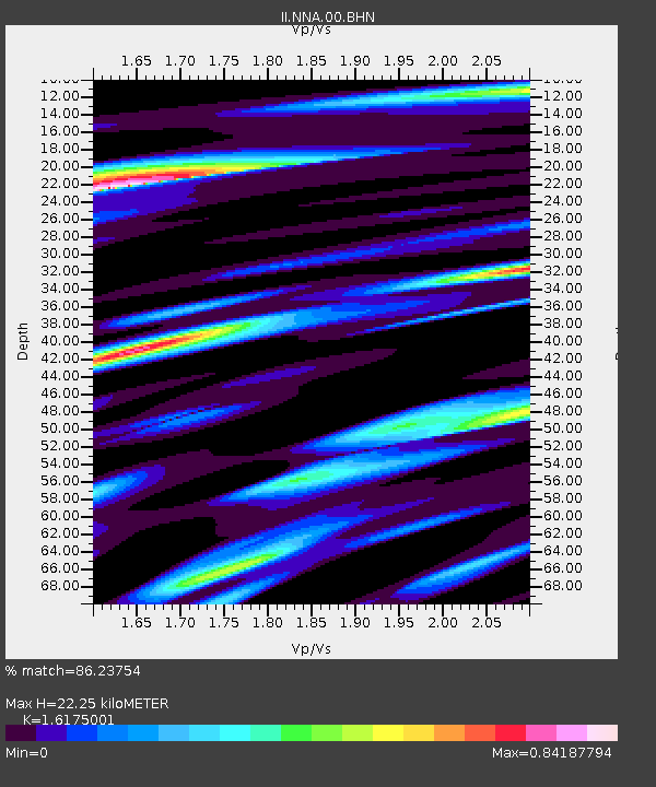
| Estimated Moho Depth: |
22.25 km |
| Estimated Crust Vp/Vs: |
1.62 |
| Assumed Crust Vp: |
6.472 km/s |
| Estimated Crust Vs: |
4.001 km/s |
| Estimated Crust Poisson's Ratio: |
0.19 |
|
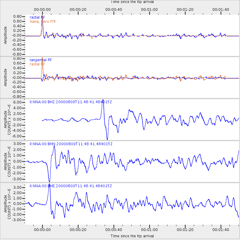
| Radial Match: |
86.23754 % |
| Radial Bump: |
400 |
| Transverse Match: |
74.216805 % |
| Transverse Bump: |
400 |
| SOD ConfigId: |
3744 |
| Insert Time: |
2010-03-01 19:51:06.332 +0000 |
| GWidth: |
2.5 |
| Max Bumps: |
400 |
| Tol: |
0.001 |
|
Signal To Noise
| Channel | StoN | STA | LTA |
| II:NNA:00:BHN:20000809T11:48:41.484015Z | 14.070329 | 1.4272572E-6 | 1.0143737E-7 |
| II:NNA:00:BHE:20000809T11:48:41.484015Z | 7.907511 | 1.5327709E-6 | 1.9383732E-7 |
| II:NNA:00:BHZ:20000809T11:48:41.484015Z | 9.381219 | 2.87639E-6 | 3.0661153E-7 |
| Arrivals |
| Ps | 2.3 SECOND |
| PpPs | 8.3 SECOND |
| PsPs/PpSs | 11 SECOND |


