You are here: Home > Network List > II - Global Seismograph Network (GSN - IRIS/IDA) Stations List
> Station NNA Nana, Peru > Earthquake Result Viewer
NNA Nana, Peru - Earthquake Result Viewer
| Earthquake location: |
Leeward Islands |
| Earthquake latitude/longitude: |
17.6/-61.2 |
| Earthquake time(UTC): |
2000/10/30 (304) 03:07:10 GMT |
| Earthquake Depth: |
33 km |
| Earthquake Magnitude: |
5.3 MB, 5.6 MS, 5.8 MW, 5.5 MD |
| Earthquake Catalog/Contributor: |
WHDF/NEIC |
|
| Network: |
II Global Seismograph Network (GSN - IRIS/IDA) |
| Station: |
NNA Nana, Peru |
| Lat/Lon: |
11.99 S/76.84 W |
| Elevation: |
575 m |
|
| Distance: |
33.2 deg |
| Az: |
208.779 deg |
| Baz: |
27.981 deg |
| Ray Param: |
0.07824245 |
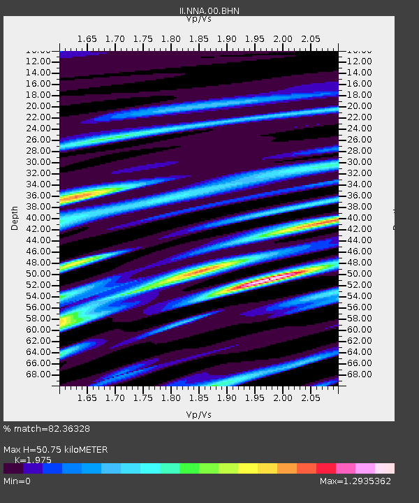
| Estimated Moho Depth: |
50.75 km |
| Estimated Crust Vp/Vs: |
1.98 |
| Assumed Crust Vp: |
6.472 km/s |
| Estimated Crust Vs: |
3.277 km/s |
| Estimated Crust Poisson's Ratio: |
0.33 |
|
| Radial Match: |
82.36328 % |
| Radial Bump: |
400 |
| Transverse Match: |
63.489594 % |
| Transverse Bump: |
400 |
| SOD ConfigId: |
3753 |
| Insert Time: |
2010-03-01 19:51:08.395 +0000 |
| GWidth: |
2.5 |
| Max Bumps: |
400 |
| Tol: |
0.001 |
|
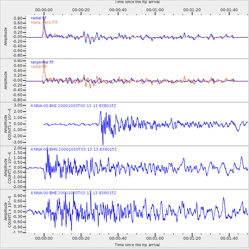
Signal To Noise
| Channel | StoN | STA | LTA |
| II:NNA:00:BHN:20001030T03:13:13.838015Z | 8.788243 | 7.129014E-7 | 8.111989E-8 |
| II:NNA:00:BHE:20001030T03:13:13.838015Z | 2.412092 | 2.5151425E-7 | 1.0427225E-7 |
| II:NNA:00:BHZ:20001030T03:13:13.838015Z | 13.393665 | 1.1764167E-6 | 8.783382E-8 |
| Arrivals |
| Ps | 8.2 SECOND |
| PpPs | 22 SECOND |
| PsPs/PpSs | 30 SECOND |


