You are here: Home > Network List > II - Global Seismograph Network (GSN - IRIS/IDA) Stations List
> Station NNA Nana, Peru > Earthquake Result Viewer
NNA Nana, Peru - Earthquake Result Viewer
| Earthquake location: |
Gulf Of California |
| Earthquake latitude/longitude: |
28.2/-112.1 |
| Earthquake time(UTC): |
2006/01/04 (004) 08:32:32 GMT |
| Earthquake Depth: |
14 km |
| Earthquake Magnitude: |
6.1 MB, 6.7 MS, 6.6 MW, 6.5 MW |
| Earthquake Catalog/Contributor: |
WHDF/NEIC |
|
| Network: |
II Global Seismograph Network (GSN - IRIS/IDA) |
| Station: |
NNA Nana, Peru |
| Lat/Lon: |
11.99 S/76.84 W |
| Elevation: |
575 m |
|
| Distance: |
52.5 deg |
| Az: |
134.602 deg |
| Baz: |
320.024 deg |
| Ray Param: |
0.066692986 |
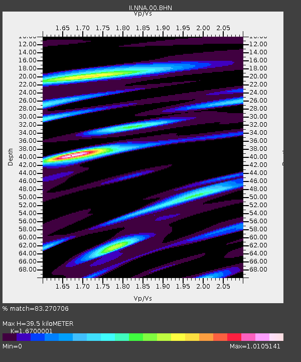
| Estimated Moho Depth: |
39.5 km |
| Estimated Crust Vp/Vs: |
1.67 |
| Assumed Crust Vp: |
6.472 km/s |
| Estimated Crust Vs: |
3.875 km/s |
| Estimated Crust Poisson's Ratio: |
0.22 |
|
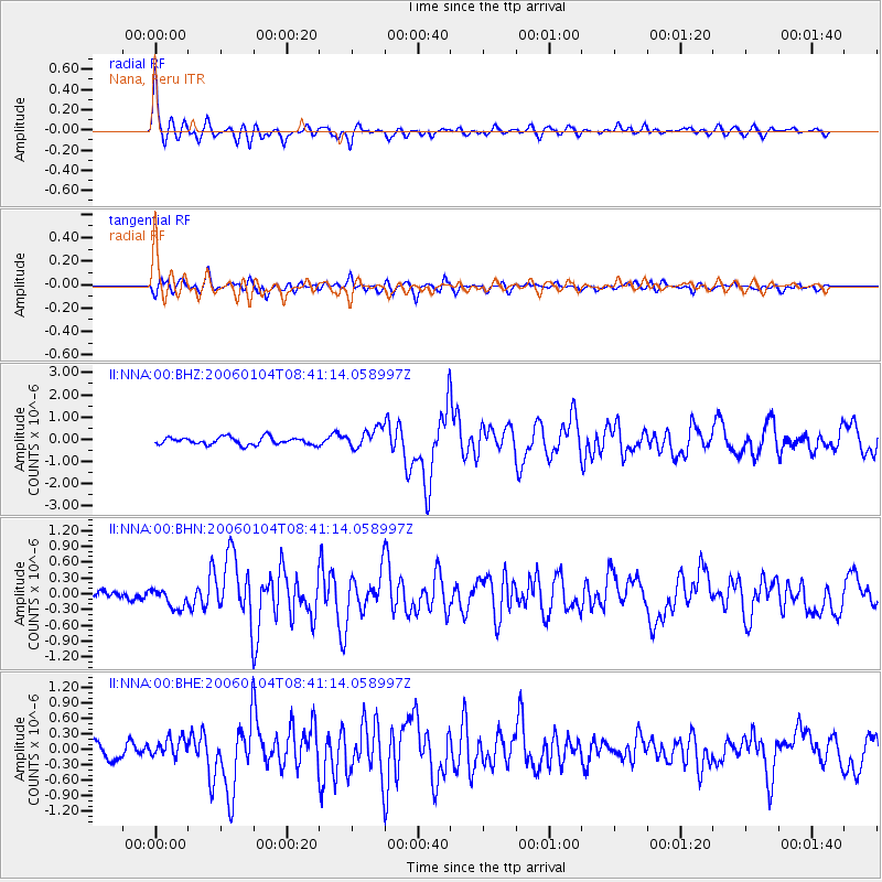
| Radial Match: |
83.270706 % |
| Radial Bump: |
391 |
| Transverse Match: |
73.332184 % |
| Transverse Bump: |
400 |
| SOD ConfigId: |
4977 |
| Insert Time: |
2010-03-01 19:51:21.520 +0000 |
| GWidth: |
2.5 |
| Max Bumps: |
400 |
| Tol: |
0.001 |
|
Signal To Noise
| Channel | StoN | STA | LTA |
| II:NNA:00:BHN:20060104T08:41:14.058997Z | 2.4638407 | 1.9127998E-7 | 7.763488E-8 |
| II:NNA:00:BHE:20060104T08:41:14.058997Z | 1.7494854 | 1.8692123E-7 | 1.06843544E-7 |
| II:NNA:00:BHZ:20060104T08:41:14.058997Z | 2.692082 | 4.469662E-7 | 1.6602995E-7 |
| Arrivals |
| Ps | 4.3 SECOND |
| PpPs | 15 SECOND |
| PsPs/PpSs | 20 SECOND |


