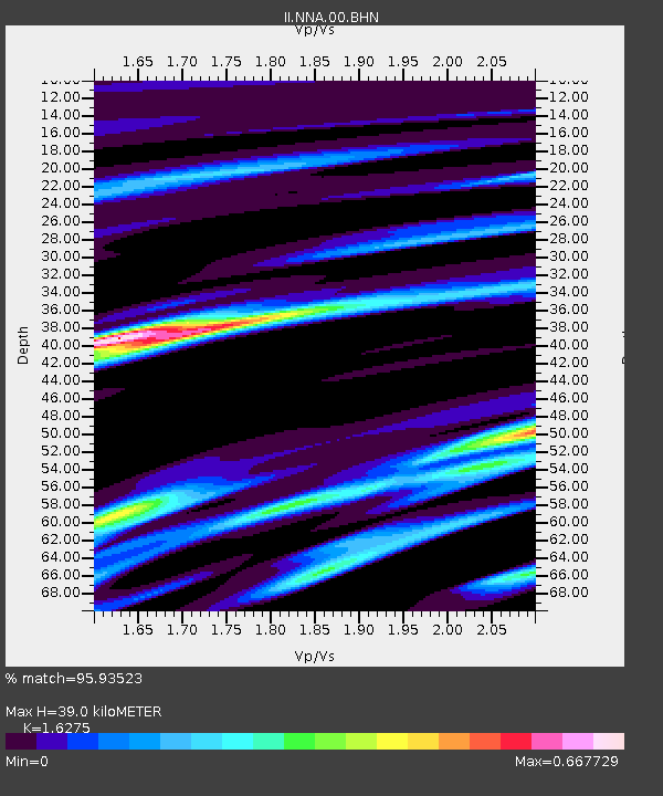
NNA Nana, Peru - Earthquake Result Viewer

Earthquake location: Southwestern Atlantic Ocean
Earthquake latitude/longitude: -60.9/-21.6
Earthquake time(UTC): 2006/01/02 (002) 06:10:49 GMT
Earthquake Depth: 10 km
Earthquake Magnitude: 6.4 MB, 7.3 MS, 7.4 MW, 7.1 MW
Earthquake Catalog/Contributor: WHDF/NEIC
Network: II Global Seismograph Network (GSN - IRIS/IDA)
Station: NNA Nana, Peru
Lat/Lon: 11.99 S/76.84 W
Elevation: 575 m
Distance: 63.1 deg
Az: 295.626 deg
Baz: 153.259 deg
Ray Param: 0.05979099
Estimated Moho Depth: 39.0 km
Estimated Crust Vp/Vs: 1.63
Assumed Crust Vp: 6.472 km/s
Estimated Crust Vs: 3.977 km/s
Estimated Crust Poisson's Ratio: 0.20
Radial Match: 95.93523 %
Radial Bump: 345
Transverse Match: 89.134544 %
Transverse Bump: 400
SOD ConfigId: 4977
Insert Time: 2010-03-01 19:51:22.866 +0000
GWidth: 2.5
Max Bumps: 400
Tol: 0.001

Signal To Noise

ChannelStoNSTALTA
II:NNA:00:BHN:20060102T06:20:45.709004Z2.9069686.387255E-72.1972224E-7
II:NNA:00:BHE:20060102T06:20:45.709004Z2.13964132.4211315E-71.1315594E-7
II:NNA:00:BHZ:20060102T06:20:45.709004Z5.0097941.4042636E-62.8030365E-7
Arrivals
Ps4.0 SECOND
PpPs15 SECOND
PsPs/PpSs19 SECOND