You are here: Home > Network List > II - Global Seismograph Network (GSN - IRIS/IDA) Stations List
> Station NNA Nana, Peru > Earthquake Result Viewer
NNA Nana, Peru - Earthquake Result Viewer

| Earthquake location: |
Tonga Islands |
| Earthquake latitude/longitude: |
-16.9/-174.2 |
| Earthquake time(UTC): |
2000/01/08 (008) 16:47:20 GMT |
| Earthquake Depth: |
183 km |
| Earthquake Magnitude: |
6.5 MB, 6.6 MS, 7.2 MW, 7.0 ME |
| Earthquake Catalog/Contributor: |
WHDF/NEIC |
|
| Network: |
II Global Seismograph Network (GSN - IRIS/IDA) |
| Station: |
NNA Nana, Peru |
| Lat/Lon: |
11.99 S/76.84 W |
| Elevation: |
575 m |
|
| Distance: |
93.5 deg |
| Az: |
103.56 deg |
| Baz: |
251.992 deg |
| Ray Param: |
0.041134838 |
| Estimated Moho Depth: |
49.25 km |
| Estimated Crust Vp/Vs: |
1.76 |
| Assumed Crust Vp: |
6.472 km/s |
| Estimated Crust Vs: |
3.682 km/s |
| Estimated Crust Poisson's Ratio: |
0.26 |
|
| Radial Match: |
92.13436 % |
| Radial Bump: |
400 |
| Transverse Match: |
77.44906 % |
| Transverse Bump: |
400 |
| SOD ConfigId: |
3744 |
| Insert Time: |
2010-03-01 19:51:32.795 +0000 |
| GWidth: |
2.5 |
| Max Bumps: |
400 |
| Tol: |
0.001 |
|
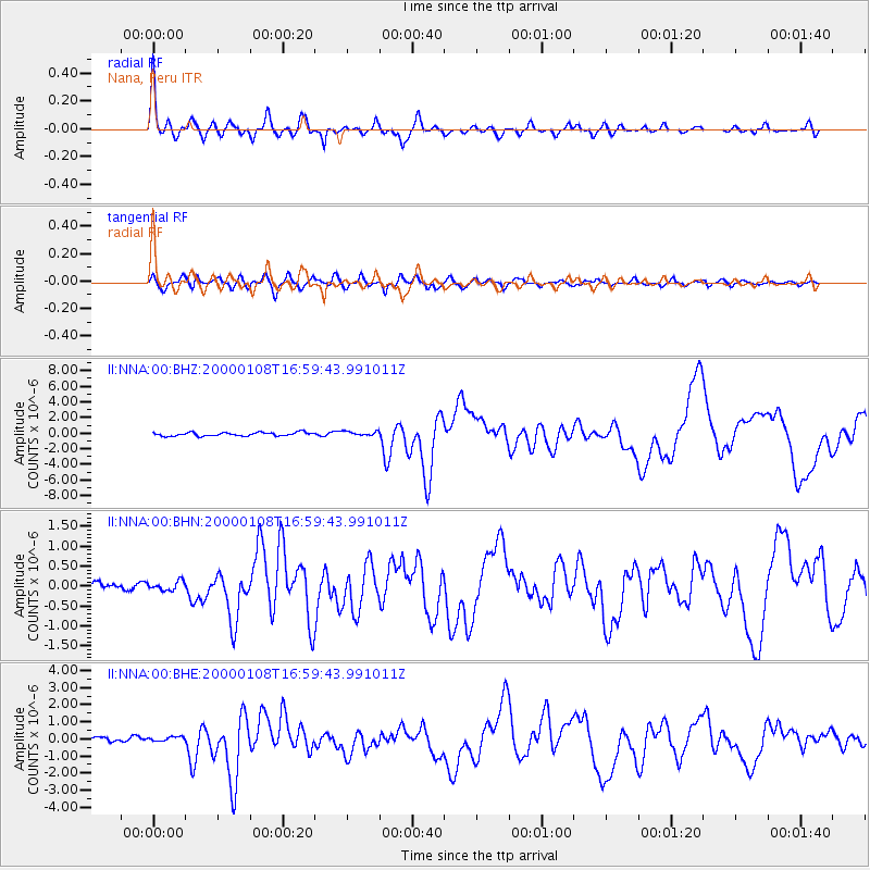
Signal To Noise
| Channel | StoN | STA | LTA |
| II:NNA:00:BHN:20000108T16:59:43.991011Z | 0.7921643 | 1.1435636E-7 | 1.4435939E-7 |
| II:NNA:00:BHE:20000108T16:59:43.991011Z | 1.5563807 | 1.5547133E-7 | 9.9892866E-8 |
| II:NNA:00:BHZ:20000108T16:59:43.991011Z | 1.2933005 | 2.9310334E-7 | 2.2663204E-7 |
| Arrivals |
| Ps | 5.9 SECOND |
| PpPs | 21 SECOND |
| PsPs/PpSs | 26 SECOND |


