You are here: Home > Network List > G - GEOSCOPE Stations List
> Station PPTF Pamatai - Papeete - Tahiti island - French Polynesia, France > Earthquake Result Viewer
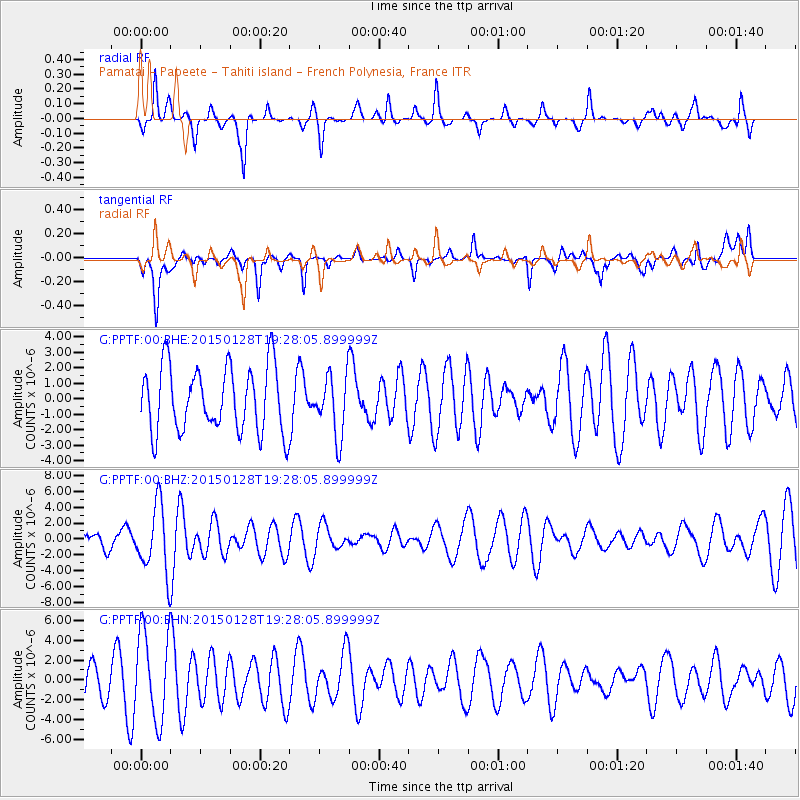
PPTF Pamatai - Papeete - Tahiti island - French Polynesia, France - Earthquake Result Viewer
*The percent match for this event was below the threshold and hence no stack was calculated.
| Earthquake location: |
Off W. Coast Of S. Island, N.Z. |
| Earthquake latitude/longitude: |
-48.5/165.0 |
| Earthquake time(UTC): |
2015/01/28 (028) 19:20:01 GMT |
| Earthquake Depth: |
35 km |
| Earthquake Magnitude: |
4.7 mb, 4.7 mb, 4.2 MS |
| Earthquake Catalog/Contributor: |
ISC/ISC |
|
| Network: |
G GEOSCOPE |
| Station: |
PPTF Pamatai - Papeete - Tahiti island - French Polynesia, France |
| Lat/Lon: |
17.59 S/149.57 W |
| Elevation: |
705 m |
|
| Distance: |
48.0 deg |
| Az: |
66.109 deg |
| Baz: |
219.57 deg |
| Ray Param: |
$rayparam |
*The percent match for this event was below the threshold and hence was not used in the summary stack. |
|
| Radial Match: |
51.726654 % |
| Radial Bump: |
287 |
| Transverse Match: |
55.606472 % |
| Transverse Bump: |
400 |
| SOD ConfigId: |
3390531 |
| Insert Time: |
2019-04-16 05:06:29.675 +0000 |
| GWidth: |
2.5 |
| Max Bumps: |
400 |
| Tol: |
0.001 |
|
Signal To Noise
| Channel | StoN | STA | LTA |
| G:PPTF:00:BHZ:20150128T19:28:05.899999Z | 1.8050002 | 4.3024547E-6 | 2.3836312E-6 |
| G:PPTF:00:BHN:20150128T19:28:05.899999Z | 2.3468978 | 4.5082465E-6 | 1.9209385E-6 |
| G:PPTF:00:BHE:20150128T19:28:05.899999Z | 0.93155897 | 1.9544648E-6 | 2.098058E-6 |
| Arrivals |
| Ps | |
| PpPs | |
| PsPs/PpSs | |


