You are here: Home > Network List > AV - Alaska Volcano Observatory Stations List
> Station MAPS Pakushin Southeast, Makushin Volcano, Alaska > Earthquake Result Viewer
MAPS Pakushin Southeast, Makushin Volcano, Alaska - Earthquake Result Viewer
*The percent match for this event was below the threshold and hence no stack was calculated.
| Earthquake location: |
Near Coast Of Northern Calif. |
| Earthquake latitude/longitude: |
40.3/-124.6 |
| Earthquake time(UTC): |
2015/01/28 (028) 21:08:53 GMT |
| Earthquake Depth: |
17 km |
| Earthquake Magnitude: |
5.7 MWW, 5.7 MWR, 5.7 MWB, 5.8 MWC |
| Earthquake Catalog/Contributor: |
NEIC PDE/NEIC COMCAT |
|
| Network: |
AV Alaska Volcano Observatory |
| Station: |
MAPS Pakushin Southeast, Makushin Volcano, Alaska |
| Lat/Lon: |
53.81 N/166.94 W |
| Elevation: |
333 m |
|
| Distance: |
31.3 deg |
| Az: |
309.824 deg |
| Baz: |
98.053 deg |
| Ray Param: |
$rayparam |
*The percent match for this event was below the threshold and hence was not used in the summary stack. |
|
| Radial Match: |
62.461536 % |
| Radial Bump: |
400 |
| Transverse Match: |
67.28237 % |
| Transverse Bump: |
400 |
| SOD ConfigId: |
3390531 |
| Insert Time: |
2019-04-16 05:08:45.553 +0000 |
| GWidth: |
2.5 |
| Max Bumps: |
400 |
| Tol: |
0.001 |
|
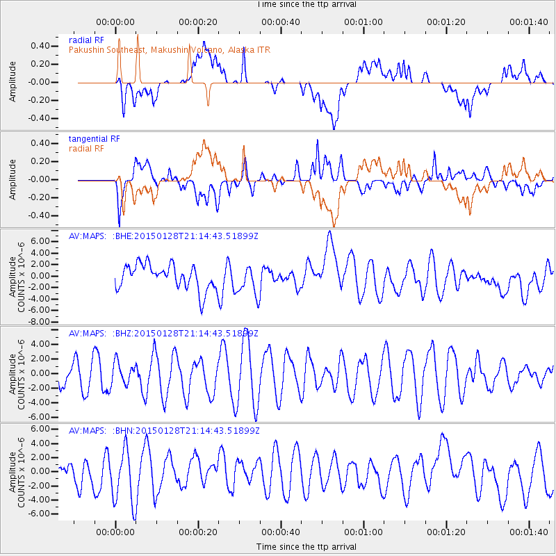
Signal To Noise
| Channel | StoN | STA | LTA |
| AV:MAPS: :BHZ:20150128T21:14:43.51899Z | 0.7728115 | 1.4258845E-6 | 1.8450613E-6 |
| AV:MAPS: :BHN:20150128T21:14:43.51899Z | 2.626767 | 4.0197574E-6 | 1.530306E-6 |
| AV:MAPS: :BHE:20150128T21:14:43.51899Z | 0.91922593 | 1.9724348E-6 | 2.1457563E-6 |
| Arrivals |
| Ps | |
| PpPs | |
| PsPs/PpSs | |


