You are here: Home > Network List > TA - USArray Transportable Network (new EarthScope stations) Stations List
> Station G59A Clarenceville, QC, USA > Earthquake Result Viewer
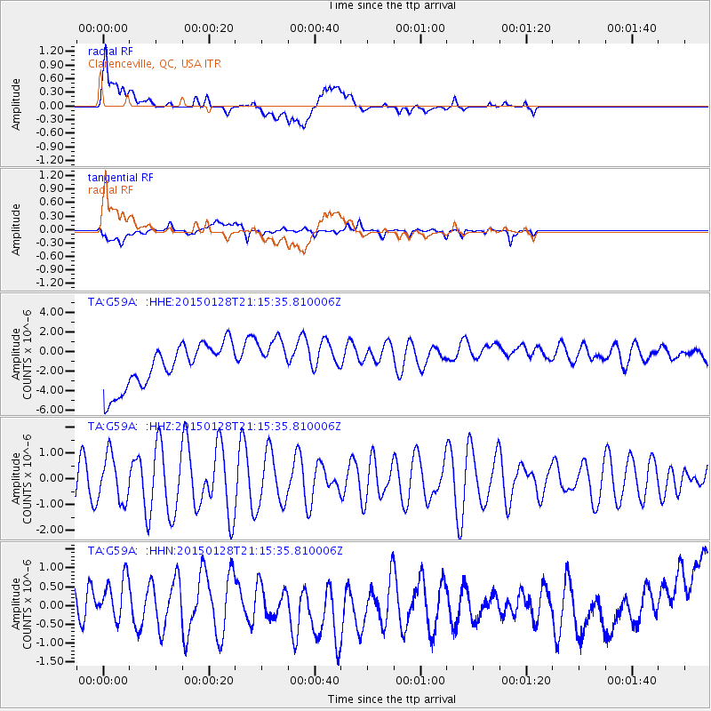
G59A Clarenceville, QC, USA - Earthquake Result Viewer
*The percent match for this event was below the threshold and hence no stack was calculated.
| Earthquake location: |
Near Coast Of Northern Calif. |
| Earthquake latitude/longitude: |
40.3/-124.6 |
| Earthquake time(UTC): |
2015/01/28 (028) 21:08:53 GMT |
| Earthquake Depth: |
17 km |
| Earthquake Magnitude: |
5.7 MWW, 5.7 MWR, 5.7 MWB, 5.8 MWC |
| Earthquake Catalog/Contributor: |
NEIC PDE/NEIC COMCAT |
|
| Network: |
TA USArray Transportable Network (new EarthScope stations) |
| Station: |
G59A Clarenceville, QC, USA |
| Lat/Lon: |
45.08 N/73.18 W |
| Elevation: |
36 m |
|
| Distance: |
37.6 deg |
| Az: |
65.289 deg |
| Baz: |
281.366 deg |
| Ray Param: |
$rayparam |
*The percent match for this event was below the threshold and hence was not used in the summary stack. |
|
| Radial Match: |
39.388386 % |
| Radial Bump: |
400 |
| Transverse Match: |
41.893578 % |
| Transverse Bump: |
400 |
| SOD ConfigId: |
3390531 |
| Insert Time: |
2019-04-16 05:12:03.821 +0000 |
| GWidth: |
2.5 |
| Max Bumps: |
400 |
| Tol: |
0.001 |
|
Signal To Noise
| Channel | StoN | STA | LTA |
| TA:G59A: :HHZ:20150128T21:15:35.810006Z | 1.1407751 | 8.766239E-7 | 7.684459E-7 |
| TA:G59A: :HHN:20150128T21:15:35.810006Z | 0.85866874 | 5.089679E-7 | 5.927407E-7 |
| TA:G59A: :HHE:20150128T21:15:35.810006Z | 0.944012 | 2.010907E-6 | 2.1301714E-6 |
| Arrivals |
| Ps | |
| PpPs | |
| PsPs/PpSs | |


