You are here: Home > Network List > TA - USArray Transportable Network (new EarthScope stations) Stations List
> Station L60A Shokan, NY, USA > Earthquake Result Viewer
L60A Shokan, NY, USA - Earthquake Result Viewer
| Earthquake location: |
Near Coast Of Northern Calif. |
| Earthquake latitude/longitude: |
40.3/-124.6 |
| Earthquake time(UTC): |
2015/01/28 (028) 21:08:53 GMT |
| Earthquake Depth: |
17 km |
| Earthquake Magnitude: |
5.7 MWW, 5.7 MWR, 5.7 MWB, 5.8 MWC |
| Earthquake Catalog/Contributor: |
NEIC PDE/NEIC COMCAT |
|
| Network: |
TA USArray Transportable Network (new EarthScope stations) |
| Station: |
L60A Shokan, NY, USA |
| Lat/Lon: |
41.99 N/74.22 W |
| Elevation: |
388 m |
|
| Distance: |
37.5 deg |
| Az: |
70.511 deg |
| Baz: |
284.791 deg |
| Ray Param: |
0.07606776 |
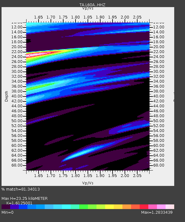
| Estimated Moho Depth: |
23.25 km |
| Estimated Crust Vp/Vs: |
1.61 |
| Assumed Crust Vp: |
6.283 km/s |
| Estimated Crust Vs: |
3.897 km/s |
| Estimated Crust Poisson's Ratio: |
0.19 |
|
| Radial Match: |
81.34013 % |
| Radial Bump: |
400 |
| Transverse Match: |
57.21049 % |
| Transverse Bump: |
400 |
| SOD ConfigId: |
3390531 |
| Insert Time: |
2019-04-16 05:12:15.878 +0000 |
| GWidth: |
2.5 |
| Max Bumps: |
400 |
| Tol: |
0.001 |
|
Signal To Noise
| Channel | StoN | STA | LTA |
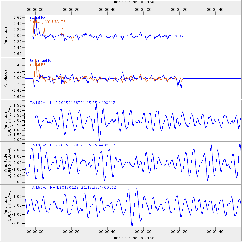
| TA:L60A: :HHZ:20150128T21:15:35.440011Z | 2.0976336 | 1.8478609E-6 | 8.8092645E-7 |
| TA:L60A: :HHN:20150128T21:15:35.440011Z | 0.76601666 | 5.717888E-7 | 7.4644436E-7 |
| TA:L60A: :HHE:20150128T21:15:35.440011Z | 1.3695856 | 8.3875597E-7 | 6.124159E-7 |
| Arrivals |
| Ps | 2.4 SECOND |
| PpPs | 8.9 SECOND |
| PsPs/PpSs | 11 SECOND |


