You are here: Home > Network List > X812 - Deep Structure of Three Continental Sutures in Eastern North America Stations List
> Station QM66 Explorers Mine, Chibougamau, Quebec, Canada > Earthquake Result Viewer
QM66 Explorers Mine, Chibougamau, Quebec, Canada - Earthquake Result Viewer
| Earthquake location: |
Near Coast Of Northern Calif. |
| Earthquake latitude/longitude: |
40.3/-124.6 |
| Earthquake time(UTC): |
2015/01/28 (028) 21:08:53 GMT |
| Earthquake Depth: |
17 km |
| Earthquake Magnitude: |
5.7 MWW, 5.7 MWR, 5.7 MWB, 5.8 MWC |
| Earthquake Catalog/Contributor: |
NEIC PDE/NEIC COMCAT |
|
| Network: |
X8 Deep Structure of Three Continental Sutures in Eastern North America |
| Station: |
QM66 Explorers Mine, Chibougamau, Quebec, Canada |
| Lat/Lon: |
49.49 N/74.44 W |
| Elevation: |
405 m |
|
| Distance: |
36.1 deg |
| Az: |
58.205 deg |
| Baz: |
274.772 deg |
| Ray Param: |
0.07684624 |
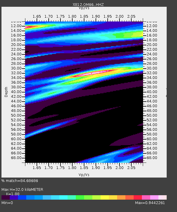
| Estimated Moho Depth: |
32.0 km |
| Estimated Crust Vp/Vs: |
1.88 |
| Assumed Crust Vp: |
6.61 km/s |
| Estimated Crust Vs: |
3.516 km/s |
| Estimated Crust Poisson's Ratio: |
0.30 |
|
| Radial Match: |
84.68686 % |
| Radial Bump: |
400 |
| Transverse Match: |
42.77118 % |
| Transverse Bump: |
400 |
| SOD ConfigId: |
3390531 |
| Insert Time: |
2019-04-16 05:13:18.850 +0000 |
| GWidth: |
2.5 |
| Max Bumps: |
400 |
| Tol: |
0.001 |
|

Signal To Noise
| Channel | StoN | STA | LTA |
| X8:QM66: :HHZ:20150128T21:15:23.389993Z | 2.2835426 | 1.2213987E-6 | 5.348701E-7 |
| X8:QM66: :HHN:20150128T21:15:23.389993Z | 2.1173725 | 8.640862E-7 | 4.0809363E-7 |
| X8:QM66: :HHE:20150128T21:15:23.389993Z | 2.1951814 | 9.187232E-7 | 4.1851808E-7 |
| Arrivals |
| Ps | 4.6 SECOND |
| PpPs | 13 SECOND |
| PsPs/PpSs | 18 SECOND |


