You are here: Home > Network List > IU - Global Seismograph Network (GSN - IRIS/USGS) Stations List
> Station RSSD Black Hills, South Dakota, USA > Earthquake Result Viewer
RSSD Black Hills, South Dakota, USA - Earthquake Result Viewer
| Earthquake location: |
Near Coast Of Northern Chile |
| Earthquake latitude/longitude: |
-19.6/-70.8 |
| Earthquake time(UTC): |
2014/04/01 (091) 23:46:46 GMT |
| Earthquake Depth: |
20 km |
| Earthquake Magnitude: |
8.2 MWW, 8.0 MI, 8.1 MWC |
| Earthquake Catalog/Contributor: |
NEIC PDE/NEIC COMCAT |
|
| Network: |
IU Global Seismograph Network (GSN - IRIS/USGS) |
| Station: |
RSSD Black Hills, South Dakota, USA |
| Lat/Lon: |
44.12 N/104.04 W |
| Elevation: |
2090 m |
|
| Distance: |
70.4 deg |
| Az: |
335.234 deg |
| Baz: |
146.754 deg |
| Ray Param: |
0.055012617 |
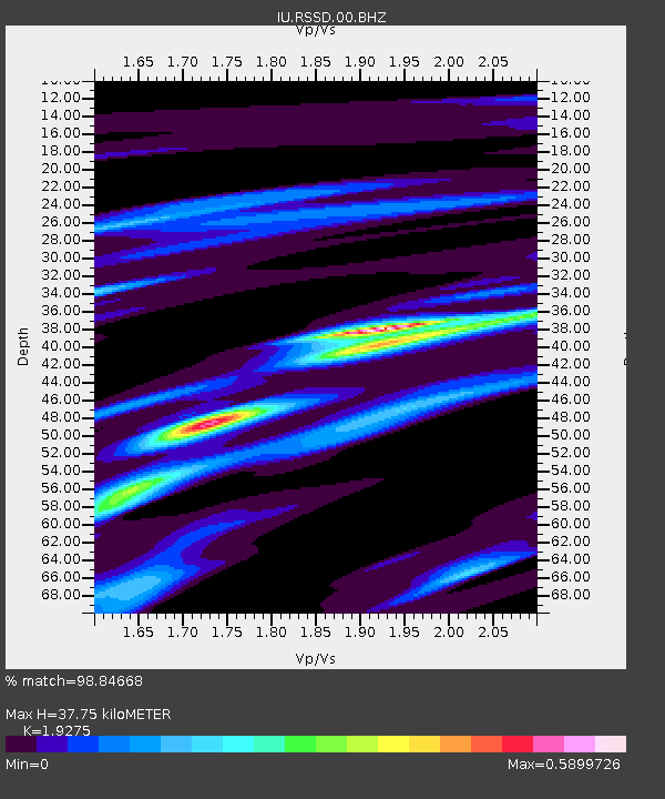
| Estimated Moho Depth: |
37.75 km |
| Estimated Crust Vp/Vs: |
1.93 |
| Assumed Crust Vp: |
6.242 km/s |
| Estimated Crust Vs: |
3.238 km/s |
| Estimated Crust Poisson's Ratio: |
0.32 |
|
| Radial Match: |
98.84668 % |
| Radial Bump: |
251 |
| Transverse Match: |
93.268234 % |
| Transverse Bump: |
400 |
| SOD ConfigId: |
626651 |
| Insert Time: |
2014-04-21 18:06:20.113 +0000 |
| GWidth: |
2.5 |
| Max Bumps: |
400 |
| Tol: |
0.001 |
|
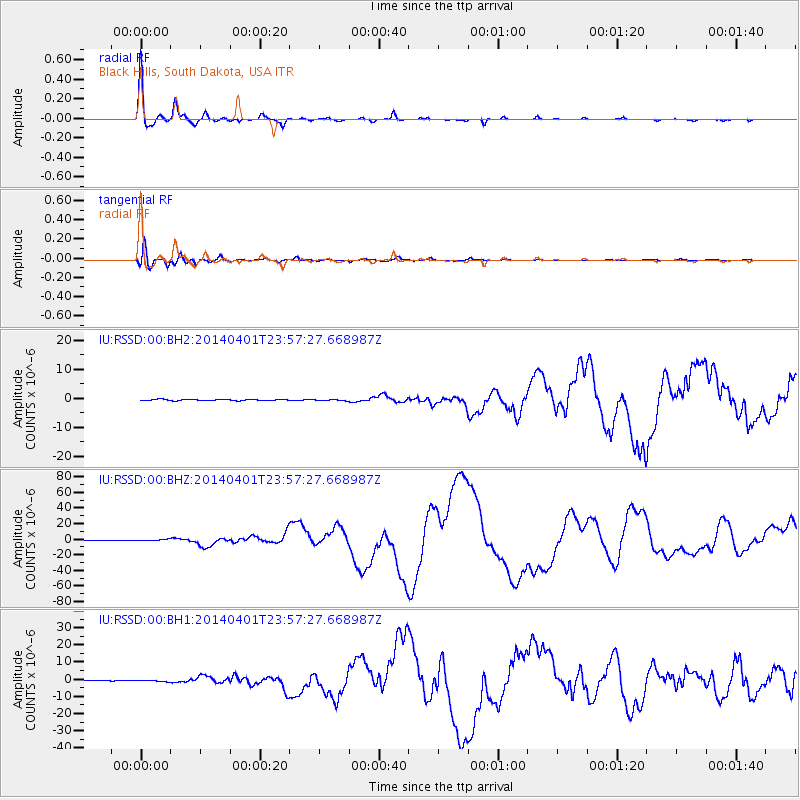
Signal To Noise
| Channel | StoN | STA | LTA |
| IU:RSSD:00:BHZ:20140401T23:57:27.668987Z | 2.5193307 | 9.514238E-7 | 3.776494E-7 |
| IU:RSSD:00:BH1:20140401T23:57:27.668987Z | 2.4841063 | 3.9465542E-7 | 1.588722E-7 |
| IU:RSSD:00:BH2:20140401T23:57:27.668987Z | 0.9234004 | 1.9122021E-7 | 2.0708266E-7 |
| Arrivals |
| Ps | 5.8 SECOND |
| PpPs | 17 SECOND |
| PsPs/PpSs | 23 SECOND |


