You are here: Home > Network List > IW - Intermountain West Stations List
> Station PHWY Pilot Hill, Wyoming, USA > Earthquake Result Viewer
PHWY Pilot Hill, Wyoming, USA - Earthquake Result Viewer
| Earthquake location: |
Near Coast Of Northern Chile |
| Earthquake latitude/longitude: |
-19.6/-70.8 |
| Earthquake time(UTC): |
2014/04/01 (091) 23:46:46 GMT |
| Earthquake Depth: |
20 km |
| Earthquake Magnitude: |
8.2 MWW, 8.0 MI, 8.1 MWC |
| Earthquake Catalog/Contributor: |
NEIC PDE/NEIC COMCAT |
|
| Network: |
IW Intermountain West |
| Station: |
PHWY Pilot Hill, Wyoming, USA |
| Lat/Lon: |
41.30 N/105.46 W |
| Elevation: |
2645 m |
|
| Distance: |
68.6 deg |
| Az: |
332.618 deg |
| Baz: |
144.876 deg |
| Ray Param: |
0.056164097 |
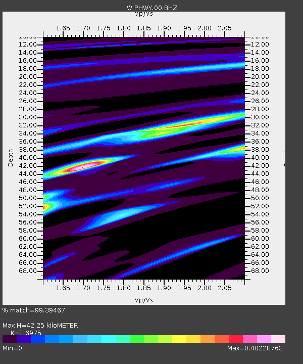
| Estimated Moho Depth: |
42.25 km |
| Estimated Crust Vp/Vs: |
1.70 |
| Assumed Crust Vp: |
6.306 km/s |
| Estimated Crust Vs: |
3.715 km/s |
| Estimated Crust Poisson's Ratio: |
0.23 |
|
| Radial Match: |
99.39467 % |
| Radial Bump: |
136 |
| Transverse Match: |
94.93244 % |
| Transverse Bump: |
400 |
| SOD ConfigId: |
626651 |
| Insert Time: |
2014-04-21 18:07:51.297 +0000 |
| GWidth: |
2.5 |
| Max Bumps: |
400 |
| Tol: |
0.001 |
|

Signal To Noise
| Channel | StoN | STA | LTA |
| IW:PHWY:00:BHZ:20140401T23:57:16.91502Z | 2.4455113 | 4.9623856E-7 | 2.0291812E-7 |
| IW:PHWY:00:BH1:20140401T23:57:16.91502Z | 1.5526038 | 2.2892326E-7 | 1.4744474E-7 |
| IW:PHWY:00:BH2:20140401T23:57:16.91502Z | 1.3430327 | 1.8048715E-7 | 1.3438775E-7 |
| Arrivals |
| Ps | 4.9 SECOND |
| PpPs | 17 SECOND |
| PsPs/PpSs | 22 SECOND |


