You are here: Home > Network List > CI - Caltech Regional Seismic Network Stations List
> Station MPM Manuel Prospect Mine, California, USA > Earthquake Result Viewer
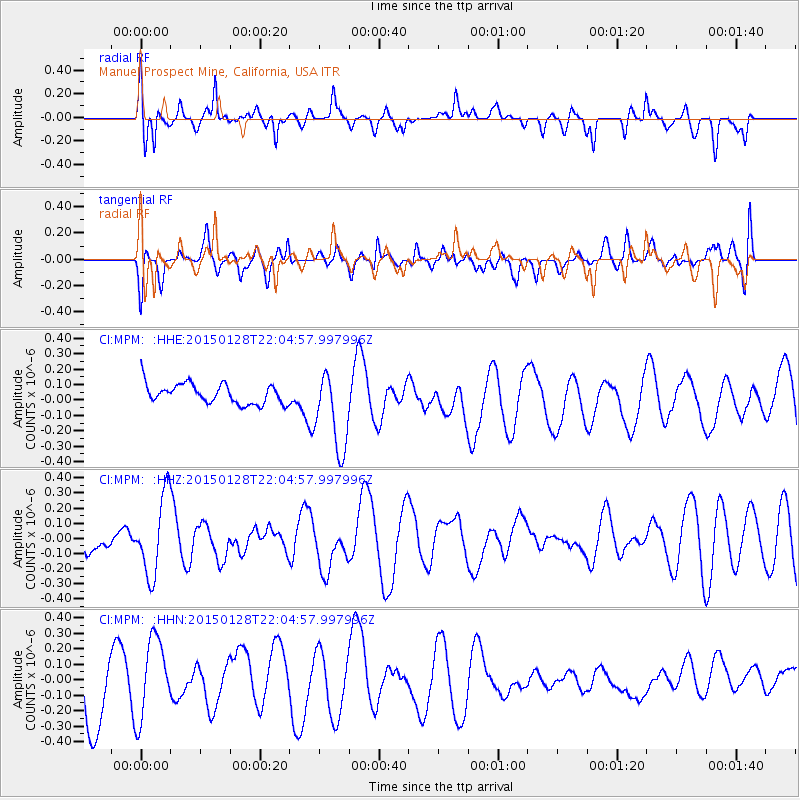
MPM Manuel Prospect Mine, California, USA - Earthquake Result Viewer
*The percent match for this event was below the threshold and hence no stack was calculated.
| Earthquake location: |
Southern East Pacific Rise |
| Earthquake latitude/longitude: |
-24.3/-116.2 |
| Earthquake time(UTC): |
2015/01/28 (028) 21:55:21 GMT |
| Earthquake Depth: |
10 km |
| Earthquake Magnitude: |
5.3 MW, 5.0 mb, 4.8 MS |
| Earthquake Catalog/Contributor: |
ISC/ISC |
|
| Network: |
CI Caltech Regional Seismic Network |
| Station: |
MPM Manuel Prospect Mine, California, USA |
| Lat/Lon: |
36.06 N/117.49 W |
| Elevation: |
185 m |
|
| Distance: |
60.1 deg |
| Az: |
358.771 deg |
| Baz: |
178.616 deg |
| Ray Param: |
$rayparam |
*The percent match for this event was below the threshold and hence was not used in the summary stack. |
|
| Radial Match: |
45.168056 % |
| Radial Bump: |
400 |
| Transverse Match: |
36.456596 % |
| Transverse Bump: |
400 |
| SOD ConfigId: |
3390531 |
| Insert Time: |
2019-04-16 05:16:27.430 +0000 |
| GWidth: |
2.5 |
| Max Bumps: |
400 |
| Tol: |
0.001 |
|
Signal To Noise
| Channel | StoN | STA | LTA |
| CI:MPM: :HHZ:20150128T22:04:57.997996Z | 1.8822483 | 2.598816E-7 | 1.3806978E-7 |
| CI:MPM: :HHN:20150128T22:04:57.997996Z | 1.1296712 | 2.6144582E-7 | 2.3143532E-7 |
| CI:MPM: :HHE:20150128T22:04:57.997996Z | 4.1200576 | 2.6317758E-7 | 6.387717E-8 |
| Arrivals |
| Ps | |
| PpPs | |
| PsPs/PpSs | |


