You are here: Home > Network List > N4 - Central and EAstern US Network Stations List
> Station E38A The Farm, Brule, WI, USA > Earthquake Result Viewer
E38A The Farm, Brule, WI, USA - Earthquake Result Viewer
| Earthquake location: |
Near Coast Of Northern Chile |
| Earthquake latitude/longitude: |
-19.6/-70.8 |
| Earthquake time(UTC): |
2014/04/01 (091) 23:46:46 GMT |
| Earthquake Depth: |
20 km |
| Earthquake Magnitude: |
8.2 MWW, 8.0 MI, 8.1 MWC |
| Earthquake Catalog/Contributor: |
NEIC PDE/NEIC COMCAT |
|
| Network: |
N4 Central and EAstern US Network |
| Station: |
E38A The Farm, Brule, WI, USA |
| Lat/Lon: |
46.61 N/91.55 W |
| Elevation: |
341 m |
|
| Distance: |
68.5 deg |
| Az: |
344.794 deg |
| Baz: |
158.988 deg |
| Ray Param: |
0.056210145 |
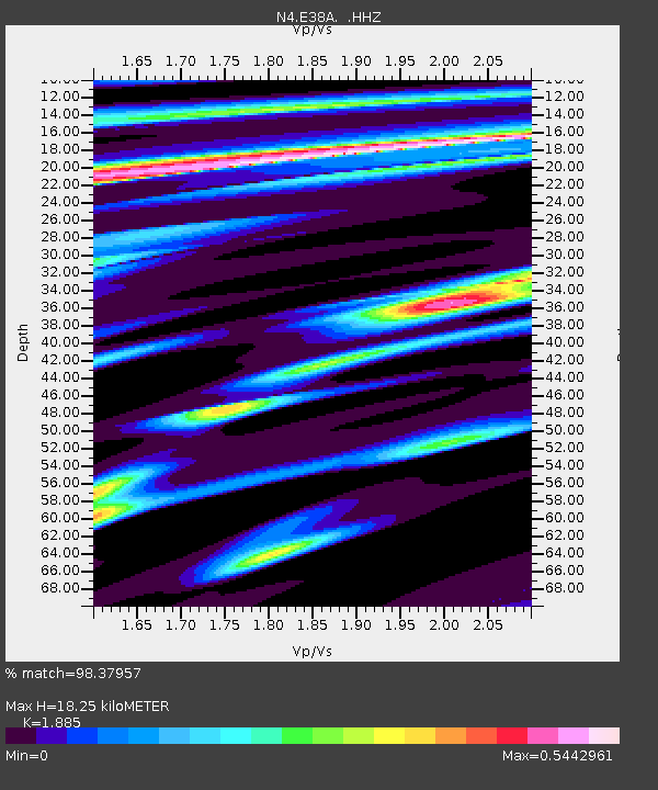
| Estimated Moho Depth: |
18.25 km |
| Estimated Crust Vp/Vs: |
1.88 |
| Assumed Crust Vp: |
6.467 km/s |
| Estimated Crust Vs: |
3.431 km/s |
| Estimated Crust Poisson's Ratio: |
0.30 |
|
| Radial Match: |
98.37957 % |
| Radial Bump: |
376 |
| Transverse Match: |
91.815094 % |
| Transverse Bump: |
400 |
| SOD ConfigId: |
626651 |
| Insert Time: |
2014-04-21 18:14:58.558 +0000 |
| GWidth: |
2.5 |
| Max Bumps: |
400 |
| Tol: |
0.001 |
|

Signal To Noise
| Channel | StoN | STA | LTA |
| N4:E38A: :HHZ:20140401T23:57:16.480022Z | 4.435552 | 1.9206934E-6 | 4.3302242E-7 |
| N4:E38A: :HHN:20140401T23:57:16.480022Z | 1.3936651 | 9.914933E-7 | 7.114287E-7 |
| N4:E38A: :HHE:20140401T23:57:16.480022Z | 1.1070619 | 3.9862178E-7 | 3.6007182E-7 |
| Arrivals |
| Ps | 2.6 SECOND |
| PpPs | 7.8 SECOND |
| PsPs/PpSs | 10 SECOND |


