You are here: Home > Network List > N4 - Central and EAstern US Network Stations List
> Station W52A Murphy, NC, USA > Earthquake Result Viewer
W52A Murphy, NC, USA - Earthquake Result Viewer
| Earthquake location: |
Near Coast Of Northern Chile |
| Earthquake latitude/longitude: |
-19.6/-70.8 |
| Earthquake time(UTC): |
2014/04/01 (091) 23:46:46 GMT |
| Earthquake Depth: |
20 km |
| Earthquake Magnitude: |
8.2 MWW, 8.0 MI, 8.1 MWC |
| Earthquake Catalog/Contributor: |
NEIC PDE/NEIC COMCAT |
|
| Network: |
N4 Central and EAstern US Network |
| Station: |
W52A Murphy, NC, USA |
| Lat/Lon: |
35.09 N/83.93 W |
| Elevation: |
519 m |
|
| Distance: |
55.8 deg |
| Az: |
347.009 deg |
| Baz: |
165.027 deg |
| Ray Param: |
0.06450766 |
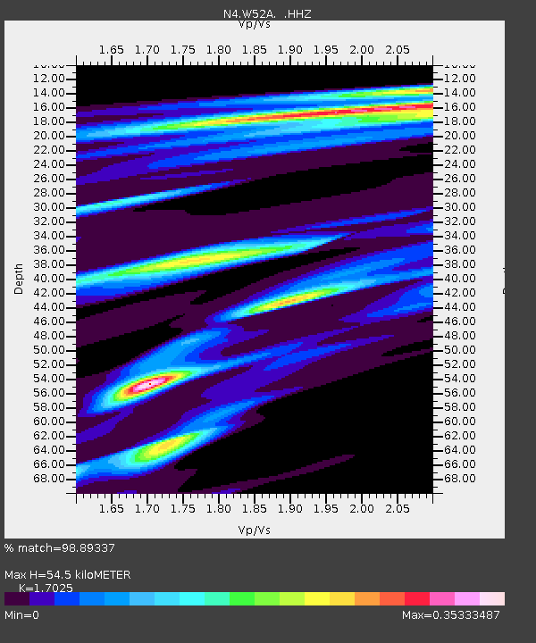
| Estimated Moho Depth: |
54.5 km |
| Estimated Crust Vp/Vs: |
1.70 |
| Assumed Crust Vp: |
6.35 km/s |
| Estimated Crust Vs: |
3.73 km/s |
| Estimated Crust Poisson's Ratio: |
0.24 |
|
| Radial Match: |
98.89337 % |
| Radial Bump: |
199 |
| Transverse Match: |
90.65529 % |
| Transverse Bump: |
400 |
| SOD ConfigId: |
626651 |
| Insert Time: |
2014-04-21 18:19:54.098 +0000 |
| GWidth: |
2.5 |
| Max Bumps: |
400 |
| Tol: |
0.001 |
|

Signal To Noise
| Channel | StoN | STA | LTA |
| N4:W52A: :HHZ:20140401T23:55:51.449993Z | 7.3516088 | 2.0483833E-6 | 2.786306E-7 |
| N4:W52A: :HHN:20140401T23:55:51.449993Z | 5.6914916 | 1.0057039E-6 | 1.7670305E-7 |
| N4:W52A: :HHE:20140401T23:55:51.449993Z | 1.9273564 | 3.567743E-7 | 1.8511072E-7 |
| Arrivals |
| Ps | 6.4 SECOND |
| PpPs | 22 SECOND |
| PsPs/PpSs | 28 SECOND |


