You are here: Home > Network List > NN - Western Great Basin/Eastern Sierra Nevada Stations List
> Station YER Yerington, Nevada w84gm > Earthquake Result Viewer
YER Yerington, Nevada w84gm - Earthquake Result Viewer
| Earthquake location: |
Near Coast Of Northern Chile |
| Earthquake latitude/longitude: |
-19.6/-70.8 |
| Earthquake time(UTC): |
2014/04/01 (091) 23:46:46 GMT |
| Earthquake Depth: |
20 km |
| Earthquake Magnitude: |
8.2 MWW, 8.0 MI, 8.1 MWC |
| Earthquake Catalog/Contributor: |
NEIC PDE/NEIC COMCAT |
|
| Network: |
NN Western Great Basin/Eastern Sierra Nevada |
| Station: |
YER Yerington, Nevada w84gm |
| Lat/Lon: |
38.99 N/119.24 W |
| Elevation: |
1857 m |
|
| Distance: |
73.9 deg |
| Az: |
322.629 deg |
| Baz: |
132.774 deg |
| Ray Param: |
0.052707743 |
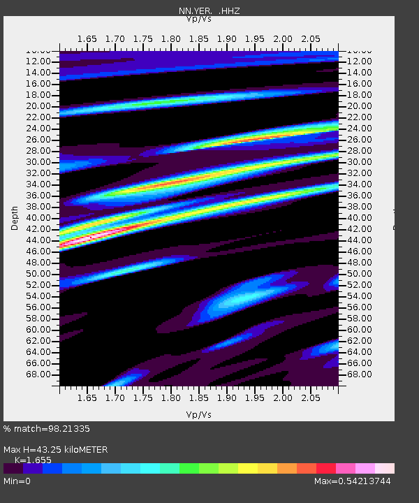
| Estimated Moho Depth: |
43.25 km |
| Estimated Crust Vp/Vs: |
1.65 |
| Assumed Crust Vp: |
6.279 km/s |
| Estimated Crust Vs: |
3.794 km/s |
| Estimated Crust Poisson's Ratio: |
0.21 |
|
| Radial Match: |
98.21335 % |
| Radial Bump: |
400 |
| Transverse Match: |
90.14883 % |
| Transverse Bump: |
400 |
| SOD ConfigId: |
626651 |
| Insert Time: |
2014-04-21 18:26:07.419 +0000 |
| GWidth: |
2.5 |
| Max Bumps: |
400 |
| Tol: |
0.001 |
|

Signal To Noise
| Channel | StoN | STA | LTA |
| NN:YER: :HHZ:20140401T23:57:48.485027Z | 1.5135859 | 3.3537512E-7 | 2.2157654E-7 |
| NN:YER: :HHN:20140401T23:57:48.485027Z | 1.1614703 | 2.7065155E-7 | 2.3302493E-7 |
| NN:YER: :HHE:20140401T23:57:48.485027Z | 3.4387043 | 5.341497E-7 | 1.5533459E-7 |
| Arrivals |
| Ps | 4.7 SECOND |
| PpPs | 18 SECOND |
| PsPs/PpSs | 22 SECOND |


