You are here: Home > Network List > TA - USArray Transportable Network (new EarthScope stations) Stations List
> Station E51A G1948 Merrick Township, ON, CAN > Earthquake Result Viewer
E51A G1948 Merrick Township, ON, CAN - Earthquake Result Viewer
| Earthquake location: |
Near Coast Of Northern Chile |
| Earthquake latitude/longitude: |
-19.6/-70.8 |
| Earthquake time(UTC): |
2014/04/01 (091) 23:46:46 GMT |
| Earthquake Depth: |
20 km |
| Earthquake Magnitude: |
8.2 MWW, 8.0 MI, 8.1 MWC |
| Earthquake Catalog/Contributor: |
NEIC PDE/NEIC COMCAT |
|
| Network: |
TA USArray Transportable Network (new EarthScope stations) |
| Station: |
E51A G1948 Merrick Township, ON, CAN |
| Lat/Lon: |
46.53 N/79.49 W |
| Elevation: |
369 m |
|
| Distance: |
66.3 deg |
| Az: |
353.471 deg |
| Baz: |
171.07 deg |
| Ray Param: |
0.057667285 |
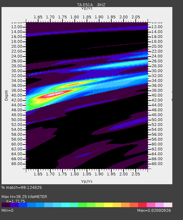
| Estimated Moho Depth: |
39.25 km |
| Estimated Crust Vp/Vs: |
1.72 |
| Assumed Crust Vp: |
6.622 km/s |
| Estimated Crust Vs: |
3.856 km/s |
| Estimated Crust Poisson's Ratio: |
0.24 |
|
| Radial Match: |
99.124825 % |
| Radial Bump: |
162 |
| Transverse Match: |
87.18534 % |
| Transverse Bump: |
400 |
| SOD ConfigId: |
626651 |
| Insert Time: |
2014-04-21 18:37:24.254 +0000 |
| GWidth: |
2.5 |
| Max Bumps: |
400 |
| Tol: |
0.001 |
|

Signal To Noise
| Channel | StoN | STA | LTA |
| TA:E51A: :BHZ:20140401T23:57:02.475017Z | 4.3748655 | 2.9005228E-6 | 6.62997E-7 |
| TA:E51A: :BHN:20140401T23:57:02.475017Z | 6.4629154 | 1.2656096E-6 | 1.9582643E-7 |
| TA:E51A: :BHE:20140401T23:57:02.475017Z | 0.65592355 | 2.9014117E-7 | 4.423399E-7 |
| Arrivals |
| Ps | 4.4 SECOND |
| PpPs | 15 SECOND |
| PsPs/PpSs | 20 SECOND |


