You are here: Home > Network List > TA - USArray Transportable Network (new EarthScope stations) Stations List
> Station H47A Mio, MI, USA > Earthquake Result Viewer
H47A Mio, MI, USA - Earthquake Result Viewer
| Earthquake location: |
Near Coast Of Northern Chile |
| Earthquake latitude/longitude: |
-19.6/-70.8 |
| Earthquake time(UTC): |
2014/04/01 (091) 23:46:46 GMT |
| Earthquake Depth: |
20 km |
| Earthquake Magnitude: |
8.2 MWW, 8.0 MI, 8.1 MWC |
| Earthquake Catalog/Contributor: |
NEIC PDE/NEIC COMCAT |
|
| Network: |
TA USArray Transportable Network (new EarthScope stations) |
| Station: |
H47A Mio, MI, USA |
| Lat/Lon: |
44.60 N/84.21 W |
| Elevation: |
356 m |
|
| Distance: |
65.1 deg |
| Az: |
349.491 deg |
| Baz: |
166.076 deg |
| Ray Param: |
0.058479585 |
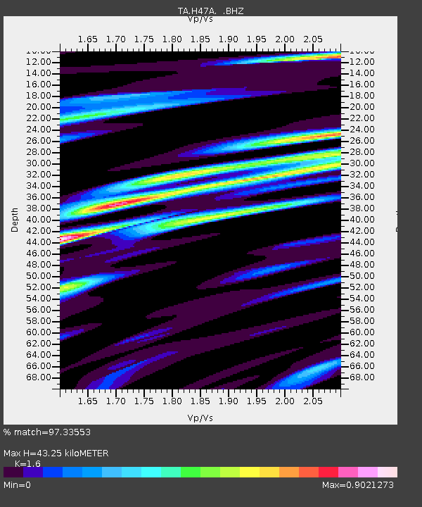
| Estimated Moho Depth: |
43.25 km |
| Estimated Crust Vp/Vs: |
1.60 |
| Assumed Crust Vp: |
6.483 km/s |
| Estimated Crust Vs: |
4.052 km/s |
| Estimated Crust Poisson's Ratio: |
0.18 |
|
| Radial Match: |
97.33553 % |
| Radial Bump: |
400 |
| Transverse Match: |
63.781956 % |
| Transverse Bump: |
400 |
| SOD ConfigId: |
626651 |
| Insert Time: |
2014-04-21 18:42:38.007 +0000 |
| GWidth: |
2.5 |
| Max Bumps: |
400 |
| Tol: |
0.001 |
|
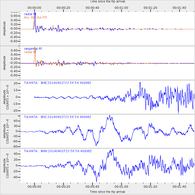
Signal To Noise
| Channel | StoN | STA | LTA |
| TA:H47A: :BHZ:20140401T23:56:54.49998Z | 2.5808225 | 2.7558115E-6 | 1.0678036E-6 |
| TA:H47A: :BHN:20140401T23:56:54.49998Z | 2.1823897 | 1.3187437E-6 | 6.042659E-7 |
| TA:H47A: :BHE:20140401T23:56:54.49998Z | 0.8706513 | 6.2327456E-7 | 7.1587164E-7 |
| Arrivals |
| Ps | 4.2 SECOND |
| PpPs | 17 SECOND |
| PsPs/PpSs | 21 SECOND |


