You are here: Home > Network List > TA - USArray Transportable Network (new EarthScope stations) Stations List
> Station I47A Gladwin, MI, USA > Earthquake Result Viewer
I47A Gladwin, MI, USA - Earthquake Result Viewer
| Earthquake location: |
Near Coast Of Northern Chile |
| Earthquake latitude/longitude: |
-19.6/-70.8 |
| Earthquake time(UTC): |
2014/04/01 (091) 23:46:46 GMT |
| Earthquake Depth: |
20 km |
| Earthquake Magnitude: |
8.2 MWW, 8.0 MI, 8.1 MWC |
| Earthquake Catalog/Contributor: |
NEIC PDE/NEIC COMCAT |
|
| Network: |
TA USArray Transportable Network (new EarthScope stations) |
| Station: |
I47A Gladwin, MI, USA |
| Lat/Lon: |
44.02 N/84.51 W |
| Elevation: |
269 m |
|
| Distance: |
64.6 deg |
| Az: |
349.101 deg |
| Baz: |
165.699 deg |
| Ray Param: |
0.058810193 |
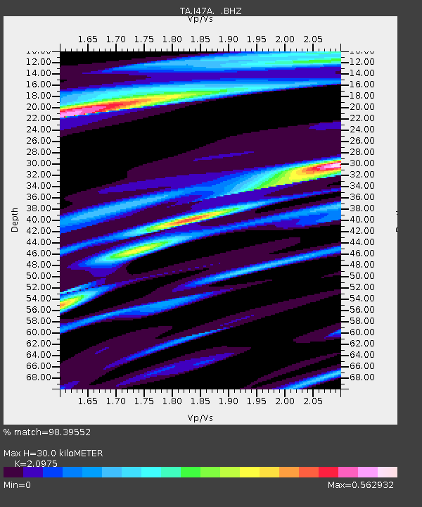
| Estimated Moho Depth: |
30.0 km |
| Estimated Crust Vp/Vs: |
2.10 |
| Assumed Crust Vp: |
6.483 km/s |
| Estimated Crust Vs: |
3.091 km/s |
| Estimated Crust Poisson's Ratio: |
0.35 |
|
| Radial Match: |
98.39552 % |
| Radial Bump: |
293 |
| Transverse Match: |
75.25599 % |
| Transverse Bump: |
400 |
| SOD ConfigId: |
626651 |
| Insert Time: |
2014-04-21 18:45:17.187 +0000 |
| GWidth: |
2.5 |
| Max Bumps: |
400 |
| Tol: |
0.001 |
|
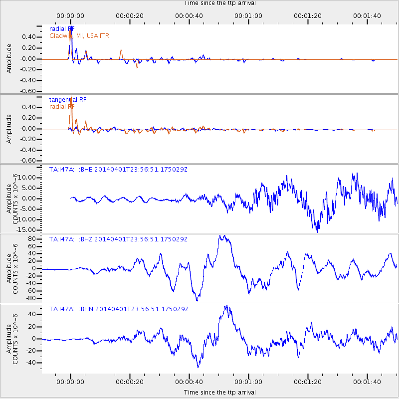
Signal To Noise
| Channel | StoN | STA | LTA |
| TA:I47A: :BHZ:20140401T23:56:51.175029Z | 5.623698 | 2.7539816E-6 | 4.897101E-7 |
| TA:I47A: :BHN:20140401T23:56:51.175029Z | 2.7037427 | 9.910375E-7 | 3.665428E-7 |
| TA:I47A: :BHE:20140401T23:56:51.175029Z | 0.46851528 | 4.050656E-7 | 8.645729E-7 |
| Arrivals |
| Ps | 5.3 SECOND |
| PpPs | 14 SECOND |
| PsPs/PpSs | 19 SECOND |


