You are here: Home > Network List > TA - USArray Transportable Network (new EarthScope stations) Stations List
> Station I55A Frankford, ON, CAN > Earthquake Result Viewer
I55A Frankford, ON, CAN - Earthquake Result Viewer
| Earthquake location: |
Near Coast Of Northern Chile |
| Earthquake latitude/longitude: |
-19.6/-70.8 |
| Earthquake time(UTC): |
2014/04/01 (091) 23:46:46 GMT |
| Earthquake Depth: |
20 km |
| Earthquake Magnitude: |
8.2 MWW, 8.0 MI, 8.1 MWC |
| Earthquake Catalog/Contributor: |
NEIC PDE/NEIC COMCAT |
|
| Network: |
TA USArray Transportable Network (new EarthScope stations) |
| Station: |
I55A Frankford, ON, CAN |
| Lat/Lon: |
44.22 N/77.68 W |
| Elevation: |
132 m |
|
| Distance: |
63.9 deg |
| Az: |
354.506 deg |
| Baz: |
172.791 deg |
| Ray Param: |
0.059282724 |
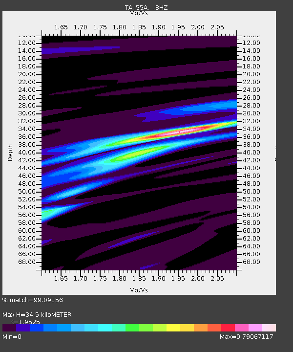
| Estimated Moho Depth: |
34.5 km |
| Estimated Crust Vp/Vs: |
1.95 |
| Assumed Crust Vp: |
6.577 km/s |
| Estimated Crust Vs: |
3.368 km/s |
| Estimated Crust Poisson's Ratio: |
0.32 |
|
| Radial Match: |
99.09156 % |
| Radial Bump: |
212 |
| Transverse Match: |
90.75376 % |
| Transverse Bump: |
400 |
| SOD ConfigId: |
626651 |
| Insert Time: |
2014-04-21 18:46:10.899 +0000 |
| GWidth: |
2.5 |
| Max Bumps: |
400 |
| Tol: |
0.001 |
|
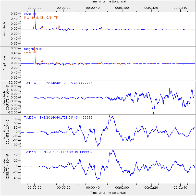
Signal To Noise
| Channel | StoN | STA | LTA |
| TA:I55A: :BHZ:20140401T23:56:46.449993Z | 4.408378 | 2.548754E-6 | 5.781614E-7 |
| TA:I55A: :BHN:20140401T23:56:46.449993Z | 1.8366594 | 1.245423E-6 | 6.780914E-7 |
| TA:I55A: :BHE:20140401T23:56:46.449993Z | 1.535182 | 6.289701E-7 | 4.0970392E-7 |
| Arrivals |
| Ps | 5.2 SECOND |
| PpPs | 15 SECOND |
| PsPs/PpSs | 20 SECOND |


