You are here: Home > Network List > IU - Global Seismograph Network (GSN - IRIS/USGS) Stations List
> Station PMG Port Moresby, New Guinea > Earthquake Result Viewer
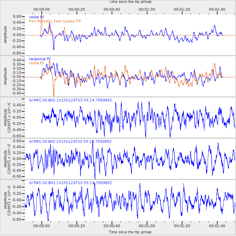
PMG Port Moresby, New Guinea - Earthquake Result Viewer
*The percent match for this event was below the threshold and hence no stack was calculated.
| Earthquake location: |
Tonga Islands |
| Earthquake latitude/longitude: |
-19.3/-174.2 |
| Earthquake time(UTC): |
2015/01/29 (029) 03:49:34 GMT |
| Earthquake Depth: |
30 km |
| Earthquake Magnitude: |
5.5 MW, 5.2 mb, 5.0 MS |
| Earthquake Catalog/Contributor: |
ISC/ISC |
|
| Network: |
IU Global Seismograph Network (GSN - IRIS/USGS) |
| Station: |
PMG Port Moresby, New Guinea |
| Lat/Lon: |
9.40 S/147.16 E |
| Elevation: |
90 m |
|
| Distance: |
38.7 deg |
| Az: |
279.232 deg |
| Baz: |
109.167 deg |
| Ray Param: |
$rayparam |
*The percent match for this event was below the threshold and hence was not used in the summary stack. |
|
| Radial Match: |
51.48649 % |
| Radial Bump: |
400 |
| Transverse Match: |
47.56846 % |
| Transverse Bump: |
400 |
| SOD ConfigId: |
3390531 |
| Insert Time: |
2019-04-16 05:26:39.112 +0000 |
| GWidth: |
2.5 |
| Max Bumps: |
400 |
| Tol: |
0.001 |
|
Signal To Noise
| Channel | StoN | STA | LTA |
| IU:PMG:00:BHZ:20150129T03:56:24.768986Z | 1.6653423 | 2.1234037E-7 | 1.2750554E-7 |
| IU:PMG:00:BH1:20150129T03:56:24.768986Z | 1.8258002 | 3.0724706E-7 | 1.6828076E-7 |
| IU:PMG:00:BH2:20150129T03:56:24.768986Z | 1.9029539 | 2.4908456E-7 | 1.3089364E-7 |
| Arrivals |
| Ps | |
| PpPs | |
| PsPs/PpSs | |


