You are here: Home > Network List > TA - USArray Transportable Network (new EarthScope stations) Stations List
> Station K48A Perry, MI, USA > Earthquake Result Viewer
K48A Perry, MI, USA - Earthquake Result Viewer
| Earthquake location: |
Near Coast Of Northern Chile |
| Earthquake latitude/longitude: |
-19.6/-70.8 |
| Earthquake time(UTC): |
2014/04/01 (091) 23:46:46 GMT |
| Earthquake Depth: |
20 km |
| Earthquake Magnitude: |
8.2 MWW, 8.0 MI, 8.1 MWC |
| Earthquake Catalog/Contributor: |
NEIC PDE/NEIC COMCAT |
|
| Network: |
TA USArray Transportable Network (new EarthScope stations) |
| Station: |
K48A Perry, MI, USA |
| Lat/Lon: |
42.80 N/84.12 W |
| Elevation: |
273 m |
|
| Distance: |
63.3 deg |
| Az: |
349.076 deg |
| Baz: |
165.955 deg |
| Ray Param: |
0.059624333 |
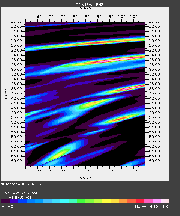
| Estimated Moho Depth: |
25.75 km |
| Estimated Crust Vp/Vs: |
1.98 |
| Assumed Crust Vp: |
6.483 km/s |
| Estimated Crust Vs: |
3.27 km/s |
| Estimated Crust Poisson's Ratio: |
0.33 |
|
| Radial Match: |
98.624855 % |
| Radial Bump: |
177 |
| Transverse Match: |
91.13805 % |
| Transverse Bump: |
400 |
| SOD ConfigId: |
626651 |
| Insert Time: |
2014-04-21 18:49:14.063 +0000 |
| GWidth: |
2.5 |
| Max Bumps: |
400 |
| Tol: |
0.001 |
|

Signal To Noise
| Channel | StoN | STA | LTA |
| TA:K48A: :BHZ:20140401T23:56:42.99998Z | 6.799123 | 2.4717385E-6 | 3.6353788E-7 |
| TA:K48A: :BHN:20140401T23:56:42.99998Z | 1.7660948 | 1.0843193E-6 | 6.1396435E-7 |
| TA:K48A: :BHE:20140401T23:56:42.99998Z | 1.4953394 | 4.886876E-7 | 3.2680714E-7 |
| Arrivals |
| Ps | 4.1 SECOND |
| PpPs | 11 SECOND |
| PsPs/PpSs | 15 SECOND |


