You are here: Home > Network List > TA - USArray Transportable Network (new EarthScope stations) Stations List
> Station Q55A Buckhannon, WV, USA > Earthquake Result Viewer
Q55A Buckhannon, WV, USA - Earthquake Result Viewer

| Earthquake location: |
Near Coast Of Northern Chile |
| Earthquake latitude/longitude: |
-19.6/-70.8 |
| Earthquake time(UTC): |
2014/04/01 (091) 23:46:46 GMT |
| Earthquake Depth: |
20 km |
| Earthquake Magnitude: |
8.2 MWW, 8.0 MI, 8.1 MWC |
| Earthquake Catalog/Contributor: |
NEIC PDE/NEIC COMCAT |
|
| Network: |
TA USArray Transportable Network (new EarthScope stations) |
| Station: |
Q55A Buckhannon, WV, USA |
| Lat/Lon: |
39.00 N/80.08 W |
| Elevation: |
657 m |
|
| Distance: |
59.0 deg |
| Az: |
351.582 deg |
| Baz: |
169.801 deg |
| Ray Param: |
0.062474504 |
| Estimated Moho Depth: |
15.75 km |
| Estimated Crust Vp/Vs: |
1.60 |
| Assumed Crust Vp: |
6.207 km/s |
| Estimated Crust Vs: |
3.879 km/s |
| Estimated Crust Poisson's Ratio: |
0.18 |
|
| Radial Match: |
98.3504 % |
| Radial Bump: |
392 |
| Transverse Match: |
93.312645 % |
| Transverse Bump: |
400 |
| SOD ConfigId: |
626651 |
| Insert Time: |
2014-04-21 19:03:14.320 +0000 |
| GWidth: |
2.5 |
| Max Bumps: |
400 |
| Tol: |
0.001 |
|
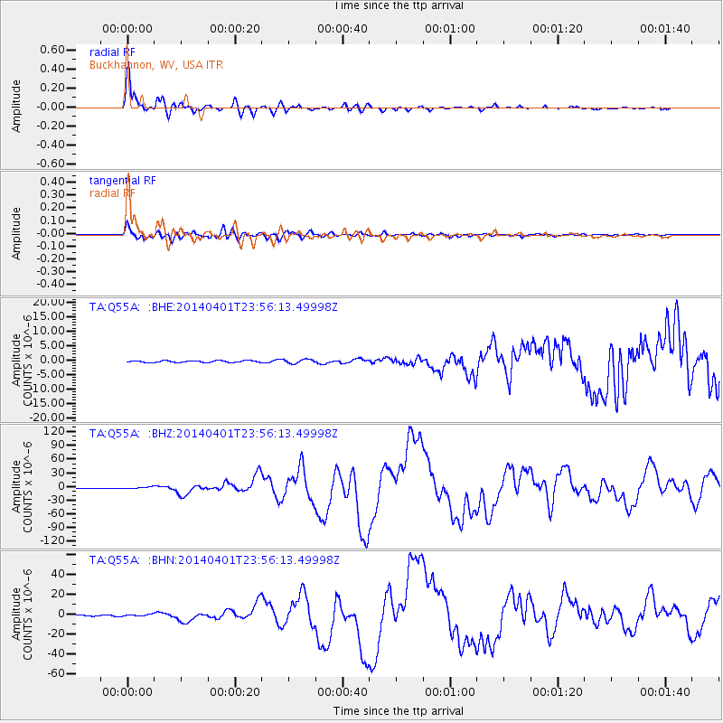
Signal To Noise
| Channel | StoN | STA | LTA |
| TA:Q55A: :BHZ:20140401T23:56:13.49998Z | 7.3481817 | 2.1716498E-6 | 2.955357E-7 |
| TA:Q55A: :BHN:20140401T23:56:13.49998Z | 1.8768667 | 9.59292E-7 | 5.1111357E-7 |
| TA:Q55A: :BHE:20140401T23:56:13.49998Z | 2.3077943 | 6.868862E-7 | 2.976375E-7 |
| Arrivals |
| Ps | 1.6 SECOND |
| PpPs | 6.3 SECOND |
| PsPs/PpSs | 7.9 SECOND |


