You are here: Home > Network List > TA - USArray Transportable Network (new EarthScope stations) Stations List
> Station S52A Salyersville, KY, USA > Earthquake Result Viewer
S52A Salyersville, KY, USA - Earthquake Result Viewer
| Earthquake location: |
Near Coast Of Northern Chile |
| Earthquake latitude/longitude: |
-19.6/-70.8 |
| Earthquake time(UTC): |
2014/04/01 (091) 23:46:46 GMT |
| Earthquake Depth: |
20 km |
| Earthquake Magnitude: |
8.2 MWW, 8.0 MI, 8.1 MWC |
| Earthquake Catalog/Contributor: |
NEIC PDE/NEIC COMCAT |
|
| Network: |
TA USArray Transportable Network (new EarthScope stations) |
| Station: |
S52A Salyersville, KY, USA |
| Lat/Lon: |
37.68 N/83.08 W |
| Elevation: |
367 m |
|
| Distance: |
58.2 deg |
| Az: |
348.561 deg |
| Baz: |
166.374 deg |
| Ray Param: |
0.062995195 |
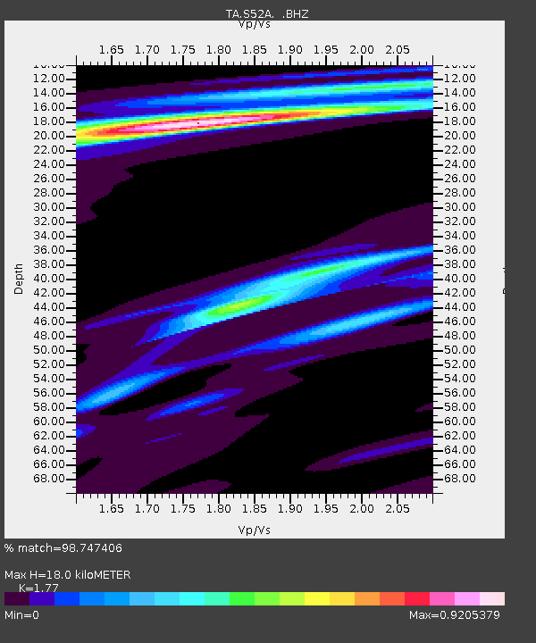
| Estimated Moho Depth: |
18.0 km |
| Estimated Crust Vp/Vs: |
1.77 |
| Assumed Crust Vp: |
6.476 km/s |
| Estimated Crust Vs: |
3.659 km/s |
| Estimated Crust Poisson's Ratio: |
0.27 |
|
| Radial Match: |
98.747406 % |
| Radial Bump: |
283 |
| Transverse Match: |
91.824875 % |
| Transverse Bump: |
400 |
| SOD ConfigId: |
626651 |
| Insert Time: |
2014-04-21 19:06:03.098 +0000 |
| GWidth: |
2.5 |
| Max Bumps: |
400 |
| Tol: |
0.001 |
|
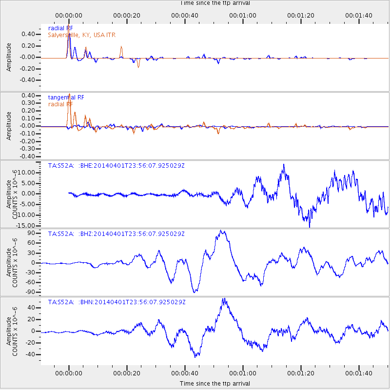
Signal To Noise
| Channel | StoN | STA | LTA |
| TA:S52A: :BHZ:20140401T23:56:07.925029Z | 2.539589 | 2.5724428E-6 | 1.0129367E-6 |
| TA:S52A: :BHN:20140401T23:56:07.925029Z | 1.8528349 | 1.44815E-6 | 7.815861E-7 |
| TA:S52A: :BHE:20140401T23:56:07.925029Z | 0.6796505 | 3.0088964E-7 | 4.4271232E-7 |
| Arrivals |
| Ps | 2.2 SECOND |
| PpPs | 7.3 SECOND |
| PsPs/PpSs | 9.6 SECOND |


