You are here: Home > Network List > TA - USArray Transportable Network (new EarthScope stations) Stations List
> Station T55A Pulaski, VA, USA > Earthquake Result Viewer
T55A Pulaski, VA, USA - Earthquake Result Viewer
| Earthquake location: |
Near Coast Of Northern Chile |
| Earthquake latitude/longitude: |
-19.6/-70.8 |
| Earthquake time(UTC): |
2014/04/01 (091) 23:46:46 GMT |
| Earthquake Depth: |
20 km |
| Earthquake Magnitude: |
8.2 MWW, 8.0 MI, 8.1 MWC |
| Earthquake Catalog/Contributor: |
NEIC PDE/NEIC COMCAT |
|
| Network: |
TA USArray Transportable Network (new EarthScope stations) |
| Station: |
T55A Pulaski, VA, USA |
| Lat/Lon: |
37.12 N/80.78 W |
| Elevation: |
644 m |
|
| Distance: |
57.2 deg |
| Az: |
350.529 deg |
| Baz: |
168.813 deg |
| Ray Param: |
0.063599885 |
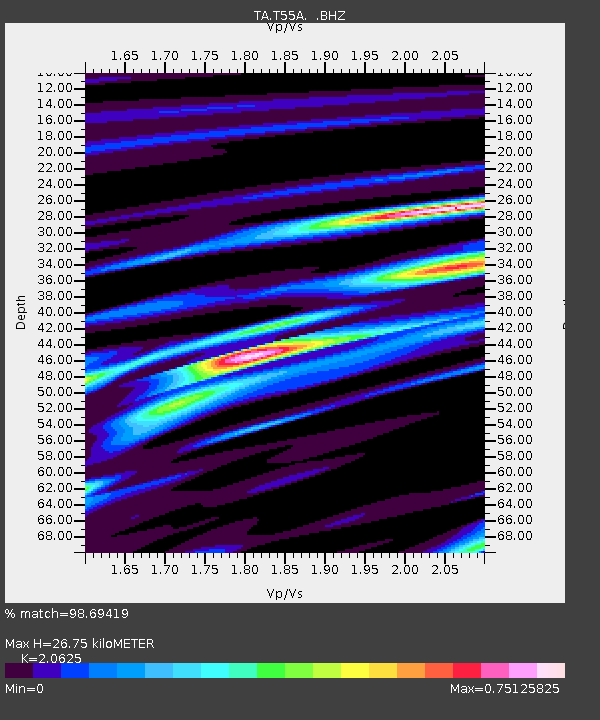
| Estimated Moho Depth: |
26.75 km |
| Estimated Crust Vp/Vs: |
2.06 |
| Assumed Crust Vp: |
6.159 km/s |
| Estimated Crust Vs: |
2.986 km/s |
| Estimated Crust Poisson's Ratio: |
0.35 |
|
| Radial Match: |
98.69419 % |
| Radial Bump: |
262 |
| Transverse Match: |
88.26008 % |
| Transverse Bump: |
400 |
| SOD ConfigId: |
626651 |
| Insert Time: |
2014-04-21 19:08:19.250 +0000 |
| GWidth: |
2.5 |
| Max Bumps: |
400 |
| Tol: |
0.001 |
|

Signal To Noise
| Channel | StoN | STA | LTA |
| TA:T55A: :BHZ:20140401T23:56:01.324993Z | 9.073467 | 2.465519E-6 | 2.7172842E-7 |
| TA:T55A: :BHN:20140401T23:56:01.324993Z | 3.8845792 | 1.1478194E-6 | 2.9548102E-7 |
| TA:T55A: :BHE:20140401T23:56:01.324993Z | 0.81962764 | 2.1865607E-7 | 2.667749E-7 |
| Arrivals |
| Ps | 4.8 SECOND |
| PpPs | 13 SECOND |
| PsPs/PpSs | 18 SECOND |


