You are here: Home > Network List > UW - Pacific Northwest Regional Seismic Network Stations List
> Station UMAT Pilot Rock, OR, USA > Earthquake Result Viewer
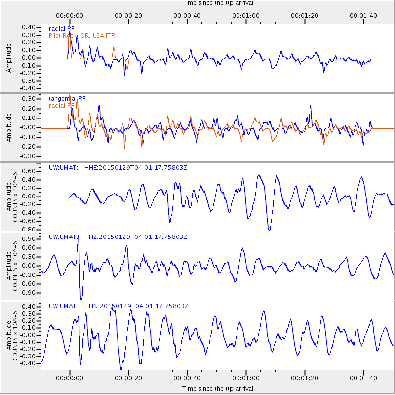
UMAT Pilot Rock, OR, USA - Earthquake Result Viewer
*The percent match for this event was below the threshold and hence no stack was calculated.
| Earthquake location: |
Tonga Islands |
| Earthquake latitude/longitude: |
-19.3/-174.2 |
| Earthquake time(UTC): |
2015/01/29 (029) 03:49:34 GMT |
| Earthquake Depth: |
30 km |
| Earthquake Magnitude: |
5.5 MW, 5.2 mb, 5.0 MS |
| Earthquake Catalog/Contributor: |
ISC/ISC |
|
| Network: |
UW Pacific Northwest Regional Seismic Network |
| Station: |
UMAT Pilot Rock, OR, USA |
| Lat/Lon: |
45.29 N/118.96 W |
| Elevation: |
1318 m |
|
| Distance: |
81.5 deg |
| Az: |
35.873 deg |
| Baz: |
231.616 deg |
| Ray Param: |
$rayparam |
*The percent match for this event was below the threshold and hence was not used in the summary stack. |
|
| Radial Match: |
59.340862 % |
| Radial Bump: |
400 |
| Transverse Match: |
64.96831 % |
| Transverse Bump: |
321 |
| SOD ConfigId: |
3390531 |
| Insert Time: |
2019-04-16 05:29:50.972 +0000 |
| GWidth: |
2.5 |
| Max Bumps: |
400 |
| Tol: |
0.001 |
|
Signal To Noise
| Channel | StoN | STA | LTA |
| UW:UMAT: :HHZ:20150129T04:01:17.75803Z | 1.6756754 | 5.294128E-7 | 3.1593996E-7 |
| UW:UMAT: :HHN:20150129T04:01:17.75803Z | 1.2365522 | 2.0600558E-7 | 1.6659675E-7 |
| UW:UMAT: :HHE:20150129T04:01:17.75803Z | 2.1544557 | 2.6035E-7 | 1.2084259E-7 |
| Arrivals |
| Ps | |
| PpPs | |
| PsPs/PpSs | |


